Sacred Geography: Pilgrimage as Civilizational Glue
National Pilgrimage Circuits and Cultural Mapping
India held a subcontinent together for millennia without constitutions or standing armies. The secret: sacred geography. Overlapping pilgrimage networks (Char Dham, Jyotirlingas, Shakti Peethas) made every Indian feel connected to places thousands of kilometers away. This lesson maps how pilgrimage circuits functioned as civilizational infrastructure, how colonial disruption weakened them, and how their revival is the most powerful tool available for civilizational renewal.
See It Today: Kedarnath's Return
In June 2013, the Kedarnath valley experienced the worst natural disaster in Uttarakhand's recorded history. A glacial lake burst above the Kedarnath temple, sending a wall of water, mud, and boulders through the town. Over 5,000 people died. The temple itself, built according to tradition by the Pandavas and reconstructed by Adi Shankaracharya in the 8th century, was buried under debris up to its shikhara. The sacred geography that had drawn millions of pilgrims for centuries was physically destroyed.
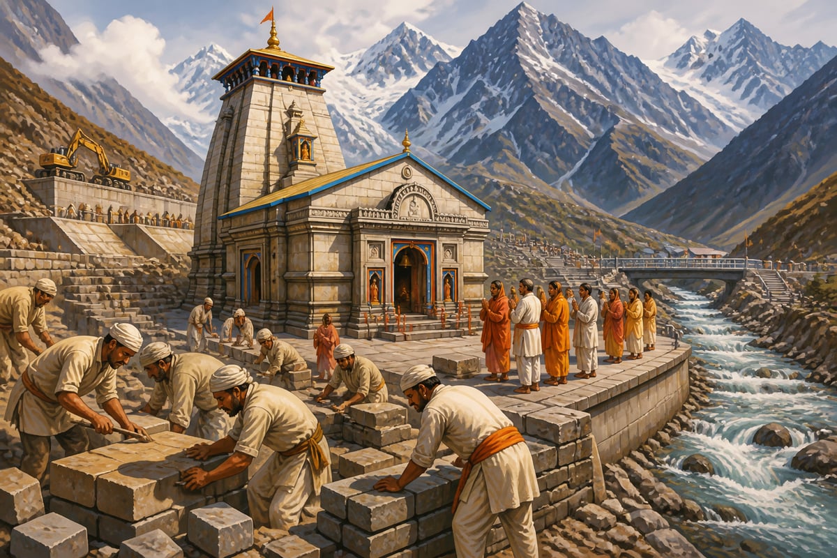
Within a decade, Kedarnath was rebuilt. Not just the temple, but the entire pilgrimage infrastructure: roads, bridges, shelters, helicopter services, and the approach paths that pilgrims had walked for centuries. By 2023, over 16 lakh pilgrims visited Kedarnath, a record that surpassed all pre-disaster numbers. The reconstruction demonstrated something that this lesson explores in depth: sacred geography is not spiritual sentiment. It is civilizational infrastructure, and civilizations that understand this rebuild it with the same urgency that nations rebuild ports and highways.
This is not an isolated story. The Kashi Vishwanath Corridor restored the ancient connection between temple and Ganga, increasing pilgrim footfall from lakhs to crores. Ujjain's Mahakal Lok project recreated the temple city's pilgrim-friendly landscape. After centuries of colonial disruption and decades of post-independence neglect, India is rediscovering what its ancestors always knew: pilgrimage circuits are not just religious routes. They are the circulatory system of civilization.
The Mechanism: How Pilgrimage Built a Nation Before Nationalism
Modern nation-states use constitutions, armies, currencies, and bureaucracies to hold territory together. India held together a subcontinent for thousands of years before any of these instruments existed. How?

The answer lies in sacred geography: the deliberate construction of pilgrimage networks that made every Indian feel connected to places thousands of kilometers from home. This was not accidental. It was civilizational engineering of the highest order.
The Architecture of Sacred Networks
India's pilgrimage geography operates through overlapping networks, each independently covering the entire subcontinent.
The Char Dham: Badrinath (north), Rameswaram (south), Dwarka (west), Puri (east). Four cardinal points that define the civilizational boundary. A pilgrim who completes the Char Dham has literally circumnavigated India's sacred geography. Attributed to Adi Shankaracharya's 8th-century vision, this circuit ensured that a Keralite had reason to travel to the Himalayas and a Kashmiri had reason to visit the southern ocean.

The 12 Jyotirlingas: Somnath (Gujarat), Mallikarjuna (Andhra Pradesh), Mahakaleshwar (Ujjain), Omkareshwar (Madhya Pradesh), Kedarnath (Uttarakhand), Bhimashankar (Maharashtra), Kashi Vishwanath (Varanasi), Trimbakeshwar (Maharashtra), Vaidyanath (Jharkhand), Nageshwar (Gujarat), Rameswaram (Tamil Nadu), Grishneshwar (Maharashtra). Twelve Shiva temples that create a web spanning every region. A Shaiva devotee's lifetime aspiration to visit all twelve required traversing the entire civilization.
The 51 Shakti Peethas: Scattered from Hinglaj (Balochistan) to Kamakhya (Assam), from Naina Devi (Himachal) to Sree Padmanabhaswamy (Kerala). The Devi worship network covered an even wider geography than the Jyotirlingas, extending beyond modern India's borders into the full extent of the civilizational footprint.
The Seven Sacred Cities (Sapta Puri): Ayodhya, Mathura, Haridwar, Varanasi, Kanchi, Ujjain, Dwarka. Cities where merely dying was believed to grant moksha. This created permanent pilgrimage magnets distributed across the subcontinent.
Each network independently covered the entire landmass. Together, they created a civilizational web so dense that no part of India was more than a few days' journey from a major pilgrimage site. Every village existed within multiple sacred geographies simultaneously.
The Five Civilizational Functions of Pilgrimage
Pilgrimage performed at least five functions that no modern institution has fully replaced.
1. Identity Integration: A Tamil Shaiva visiting Kashi Vishwanath and a Bihari Shaiva visiting Rameswaram experienced the same civilization through different regional lenses. The shared mythology (the Jyotirlinga narrative from the Shiva Purana) gave them a common story. The shared ritual practice gave them a common experience. They returned home knowing, in their bones, that they belonged to something larger than their village or region.
2. Knowledge Exchange: Pilgrimage routes were India's original information highways. Pilgrims carried stories, songs, medical knowledge, agricultural techniques, craft traditions, and philosophical ideas across linguistic boundaries. The Bhakti movement spread along pilgrimage routes. Ramanuja's Vaishnavism traveled from Tamil Nadu to Varanasi and back along pilgrim corridors. Ideas that would have taken generations to spread through isolated communities traveled in years through pilgrim networks.
3. Economic Integration: Every major pilgrimage site generated a local economy: dharamshalas, food stalls, flower markets, textile traders, boatmen, guides, astrologers, artisans. Pilgrim routes created trade corridors. The Kashi-Rameswaram axis was simultaneously a spiritual highway and a commercial artery. Spices moved north. Banarasi silk moved south. Money, goods, and skills flowed along paths originally walked for darshan.
4. Linguistic Bridge-Building: At major pilgrimage sites, Indians who spoke mutually unintelligible languages had to communicate. This created pidgin vocabularies, multilingual priests, and a practical cosmopolitanism that no government program could replicate. Sanskrit functioned as the link language of pilgrimage, making temple rituals comprehensible from Somnath to Rameswaram.
5. Constitutional Function: The concept of Bharatavarsha as a unified civilizational space was not an abstraction taught in classrooms. It was a lived experience for every pilgrim who walked from their village to a distant sacred site. The Vishnu Purana defines Bharatavarsha geographically. Pilgrimage made that geography experiential. You knew India was one civilization because you had walked through it.
Why Colonial Powers Targeted Sacred Geography
Colonial administrators understood pilgrimage's civilizational function, even if they would not have used that language. The Pilgrim Tax, imposed by British authorities on major pilgrimage sites, was not primarily a revenue measure. It was a civilizational disruption tool. By making pilgrimage expensive, the British reduced the frequency and scale of the very activity that held India's civilizational consciousness together.
The destruction of temple economies (which funded dharamshalas, fed pilgrims, and maintained routes) further weakened the pilgrim network. When the British took control of major temple endowments, and post-independence governments continued this through acts like the various Hindu Religious Endowments Acts, they severed the financial arteries that sustained sacred geography.
The result was predictable. Pilgrimage did not stop, but it shrank. Routes deteriorated. Dharamshalas decayed. The economic networks that sustained pilgrim corridors contracted. The civilizational glue weakened, not because Indians stopped believing, but because the infrastructure of belief was systematically degraded.
The Pattern: How the 12 Jyotirlingas Built a Civilizational Web
The most elegant example of pilgrimage as civilizational architecture is the 12 Jyotirlinga network. Twelve temples dedicated to Shiva, distributed across the subcontinent with a precision that suggests deliberate civilizational design rather than organic accumulation.
Consider the geographic distribution. Somnath anchors the western coast (Gujarat). Mallikarjuna covers the Deccan (Andhra Pradesh). Mahakaleshwar and Omkareshwar hold central India (Madhya Pradesh). Kedarnath marks the Himalayan north (Uttarakhand). Kashi Vishwanath dominates the Gangetic heartland (Uttar Pradesh). Bhimashankar, Trimbakeshwar, and Grishneshwar create a dense cluster in Maharashtra's Western Ghats. Vaidyanath extends into the eastern tribal belt (Jharkhand). Nageshwar provides a second western anchor (Gujarat). Rameswaram reaches India's southernmost sacred tip (Tamil Nadu).
This is not a random scatter. It is a network designed to ensure that no major region of the subcontinent exists outside the Jyotirlinga geography. A Shaiva devotee aspiring to visit all twelve would, in the process, traverse the entire civilization: desert and coast, mountain and plain, Tamil and Sanskrit, tribal and urban.
The Shiva Purana's narrative of the Jyotirlinga (a column of infinite light that Brahma and Vishnu could not measure) provides the theological framework. But the civilizational function goes far beyond theology. Each Jyotirlinga became an anchor point for regional sacred geography. Somnath was not just a temple; it was the hub of a pilgrim economy that connected Gujarat's coast to inland trade routes. Rameswaram was not just a shrine; it was the southern terminus of the Kashi-Rameswaram corridor that stitched North and South India together.
When Mahmud of Ghazni destroyed Somnath in 1026 CE, Indians rebuilt it. When it was destroyed again, they rebuilt it again. This is not stubbornness. It is the civilizational immune system responding to an attack on its infrastructure. Destroying a Jyotirlinga was not destroying a building. It was severing a node in the civilizational network. Rebuilding it was reconnecting the network.
The Jyotirlinga system demonstrates the genius of India's distributed sacred geography. Unlike civilizations that concentrate sanctity in a single location (Jerusalem, Mecca, Rome), India distributed sanctity across an entire subcontinent. The destruction of one node does not destroy the network. The civilization is distributed, resilient, and self-healing.
Dharmic Wisdom: Tirtha and the Sacred Map
The Sanskrit concept of Tirtha (sacred crossing point) reveals how sophisticated India's sacred geography truly was. A Tirtha is literally a "ford": a place where one crosses from the mundane to the sacred. But the concept operates at multiple levels simultaneously.
A geographical Tirtha is a physical location: a river confluence, a mountain peak, a temple site. But the Mahabharata's Tirtha Yatra Parva (the Pilgrimage Section, one of the longest in the epic) systematically maps the entire subcontinent through Tirtha descriptions, creating what is effectively a sacred atlas of Bharatavarsha. When Pulastya describes the Tirthas to Bhishma, he is teaching geography, history, mythology, and Dharma simultaneously.
The genius of the Tirtha concept is that it made geography sacred and sacredness geographical. You could not worship the Ganga without knowing where it flowed. You could not honor the Jyotirlingas without knowing where each one stood. Devotion required travel. Spirituality required physical engagement with the land.
This stands in contrast to Abrahamic sacred geography, which concentrates sanctity in a single city or site. Indian sacred geography distributes sanctity across an entire subcontinent, making every region sacred and every region connected. No single point of failure exists. The civilization is architecturally resilient.
The Defense: Rebuilding Sacred Geography for the 21st Century
The revival of sacred geography is already underway, but it needs strategic depth to reach its civilizational potential. Kedarnath's reconstruction proved that Indians will invest massively in sacred geography when the opportunity exists. Now the task is to think systematically.
What Is Already Working
The Kedarnath reconstruction transformed a disaster into a demonstration of civilizational resilience. The Kashi Vishwanath Corridor proved that physical restoration of sacred spaces can increase pilgrim engagement by orders of magnitude. Major temple renovation projects across the country are restoring sacred sites that had deteriorated for decades. The Chardham Highway project is making the Himalayan pilgrimage circuit accessible year-round. These projects share a common insight: sacred geography is infrastructure, and infrastructure investment pays civilizational dividends.
Six Strategic Priorities for Revival
1. Map the Sacred Geography Systematically: India has never conducted a comprehensive survey of its sacred geography: every Tirtha, every temple, every sacred grove, every river crossing, every pilgrimage route. A Sacred Geography Atlas of India, combining satellite mapping, archaeological records, literary references from the Puranas to medieval travelogues, and local oral traditions, would be the foundation for all revival efforts.
2. Restore Pilgrim Walking Routes: The ancient walking routes between major sacred sites need physical restoration: marked paths, dharamshalas at traditional waypoints, safety infrastructure, and wayfinding systems. Spain revived a single medieval pilgrimage route (Camino de Santiago) into a global cultural phenomenon drawing 400,000 walkers annually. India has hundreds of such routes, most unmarked and unmaintained. Even restoring ten major walking routes would create an unparalleled civilizational tourism network.
3. Revive Pilgrim Trade Networks: Every restored pilgrimage route should simultaneously function as an economic corridor. Local artisans, food producers, hospitality providers, and cultural performers along the route should be supported to create a pilgrim economy that benefits villages between major sites, not just the endpoint temples. The goal is recreating the Kashi-Rameswaram model where spiritual and economic flows reinforced each other.
4. Create Inter-Regional Pilgrimage Exchanges: Organized pilgrimage exchanges between regions (Tamil groups visiting Kashi, Banarasi groups visiting Rameswaram, Northeastern communities visiting Dwarka) would rebuild the civilizational cross-pollination that made India cohere for millennia. These exchanges should include cultural programming: local music, food, storytelling, and craft demonstrations that make pilgrimage a full civilizational experience.
5. Sacred Geography Education: Every Indian child should know the Char Dham, the Jyotirlingas, the Shakti Peethas, and the Sapta Puri. This is not religious instruction. It is civilizational literacy. Knowing that Somnath is in Gujarat and Rameswaram is in Tamil Nadu and both are part of the same sacred network teaches a child that India is one civilization more effectively than any textbook can.
6. Digital Sacred Geography: Apps and platforms that map sacred sites, provide historical context, offer multilingual audio guides, and connect pilgrims with local communities can make sacred geography accessible to a generation that navigates by smartphone. Augmented reality overlays at sacred sites can connect today's visitor with a site's millennia-deep history, making the Tirtha concept come alive for digital natives.
The pilgrimage networks that unified India for thousands of years were the product of civilizational genius. No constitution, no army, no bureaucracy achieved what the Char Dham, the Jyotirlingas, and the Tirtha system achieved: making hundreds of millions of people feel that they belong to one civilization. Rebuilding this sacred geography is not nostalgia. It is the most powerful tool available for civilizational renewal.
Case studies
The 12 Jyotirlinga Circuit: A Civilizational Web in Stone
Twelve temples dedicated to Shiva are distributed across the Indian subcontinent with a geographic precision that suggests deliberate civilizational design. Somnath anchors the western coast in Gujarat. Mallikarjuna covers the Deccan in Andhra Pradesh. Mahakaleshwar and Omkareshwar hold central India in Madhya Pradesh. Kedarnath marks the Himalayan north in Uttarakhand. Kashi Vishwanath dominates the Gangetic heartland. Bhimashankar, Trimbakeshwar, and Grishneshwar create a dense cluster in Maharashtra's Western Ghats. Vaidyanath extends into the eastern tribal belt of Jharkhand. Nageshwar provides a second western anchor in Gujarat. Rameswaram reaches India's southernmost sacred tip in Tamil Nadu. No major region of the subcontinent exists outside this network. The Shiva Purana provides the theological narrative: Shiva manifested as an infinite column of light at each location, making each site eternally charged with divine presence.
The Shiva Purana's Jyotirlinga narrative transforms geography into theology and theology into civilizational infrastructure. The Vishnu Purana defined Bharatavarsha as the land between the Himalayas and the ocean. The Jyotirlinga network fills that geography with sacred anchor points. Each Jyotirlinga functions as what the Arthashastra would call a Durga (strategic node): a point that anchors surrounding territory into a coherent whole. The repeated rebuilding of Somnath after destruction by Mahmud of Ghazni (1026 CE) and subsequent invaders demonstrates the civilizational immune response. Destroying a Jyotirlinga was not destroying a building. It was severing a node in the civilizational network. Rebuilding it was reconnecting that network.
The Jyotirlinga network has survived over a millennium of invasions, colonial disruption, and post-independence neglect. Somnath was rebuilt at least seven times. Every Jyotirlinga remains an active pilgrimage site today. The network continues to draw millions of pilgrims annually, demonstrating that distributed sacred geography is architecturally resilient in ways that centralized sacred sites are not.
India distributed sanctity across an entire subcontinent rather than concentrating it in a single location. This made the civilization's sacred infrastructure resilient to any single point of attack. The destruction of one node does not destroy the network. This distributed architecture is the deepest structural lesson of Indian sacred geography.
The Jyotirlinga network remains one of India's most powerful integrating forces. A Shaiva devotee in Tamil Nadu and one in Gujarat share the same aspiration to visit all twelve. In an age of regional fragmentation and identity politics, the pilgrimage circuits that connect Indians across linguistic and regional boundaries are more valuable than ever.
Somnath Temple has been destroyed and rebuilt at least seven times across roughly 1,000 years. The current structure, initiated by Sardar Vallabhbhai Patel in 1950 and completed in 1951, now receives over 1 crore visitors annually. No other sacred site in world history has been rebuilt this many times.
The Kashi-Rameswaram Corridor: India's Civilizational Spine
For centuries, one of India's most important pilgrimage routes connected Varanasi (Kashi) in the Gangetic north to Rameswaram at the subcontinent's southern tip. This was not merely a spiritual path. It was a civilizational corridor that stitched together the entire north-south geography of India. Pilgrims walking from Kashi to Rameswaram traversed the Gangetic plain, crossed into the Deccan, passed through Dravidian linguistic territory, and arrived at the point where Rama is said to have built the bridge to Lanka. Along the route, a chain of sacred waypoints created a network of local economies: Prayagraj (the sangam), Chitrakoot (Rama's exile), Srisailam (Mallikarjuna Jyotirlinga), Tirupati (Venkateshwara), and finally Rameswaram. The corridor also functioned as a trade route. Tamil merchants carried spices, pearls, and textiles northward. Banarasi traders carried silk, brassware, and sacred thread southward. Hundi banking networks operated along the route, creating a financial system that predated modern banking by centuries.
The Kashi-Rameswaram corridor embodies the Vishnu Purana's definition of Bharatavarsha as a unified civilizational space between the Himalayas and the ocean. The pilgrim walking this route was physically enacting the unity of what colonial and modern narratives attempt to separate as 'Aryan north' and 'Dravidian south.' The Mahabharata's Tirtha Yatra Parva describes precisely this kind of corridor: a sequence of Tirthas that, when visited in order, takes the pilgrim through the full geography of Bharatavarsha. The corridor's dual function as spiritual highway and commercial artery reflects Kautilya's principle that trade routes and pilgrimage routes should reinforce each other, creating economic incentives for civilizational cohesion.
The British disrupted the corridor through pilgrim taxes that made pilgrimage expensive, railway routes that bypassed traditional sacred waypoints, and administrative boundaries that cut across pilgrimage paths. The old walking routes became economically unviable. Dharamshalas along the route decayed. The pilgrim trade networks that sustained villages between the two endpoints collapsed. The civilizational integration function weakened as pilgrimage became a transactional railway journey rather than an embodied civilizational experience.
Pilgrimage corridors were simultaneously spiritual highways, trade routes, and civilizational integrators. When colonial policy disrupted them, it was not just religious practice that suffered. It was the economic, linguistic, and identity-building functions that pilgrimage performed. Restoring these corridors means restoring all their functions, not just the spiritual one.
The Kashi-Rameswaram corridor model is directly relevant to modern proposals for pilgrimage tourism circuits. Restoring even portions of the old walking route with marked paths, dharamshalas, and support for local artisans could create economic corridors that simultaneously rebuild civilizational consciousness.
The Kashi-Rameswaram corridor spans approximately 2,200 kilometers. Pre-colonial pilgrims walked this distance over 60-90 days, passing through at least 6 major language zones and dozens of sacred waypoints. The corridor's pilgrim trade networks supported an estimated chain of over 1,000 dharamshalas, rest houses, and feeding stations along its length.
Kedarnath Reconstruction: Civilizational Resilience After Catastrophe
On June 16-17, 2013, a glacial lake burst above the Kedarnath valley in Uttarakhand, triggering catastrophic flooding and landslides. The Kedarnath temple, one of the 12 Jyotirlingas and the northernmost point of the Char Dham circuit, was buried under meters of debris. Over 5,000 people died in the broader Uttarakhand disaster, with Kedarnath bearing the worst destruction. The temple itself survived structurally, protected by a massive boulder that diverted the main flow of debris, but the surrounding infrastructure was completely destroyed: roads, bridges, approach paths, dharamshalas, shops, and helicopter pads. The entire pilgrimage ecosystem that had sustained Kedarnath for centuries was wiped out in hours. Within a decade, a comprehensive reconstruction effort rebuilt not just the temple but the entire pilgrimage infrastructure. New roads, bridges, retaining walls, and approach paths were constructed. The temple was restored and a new courtyard built. Helicopter services were expanded. Safety infrastructure including early warning systems was installed.
Kedarnath's reconstruction mirrors the civilizational pattern visible throughout Indian history: the rebuilding of Somnath after repeated destruction, the restoration of Kashi Vishwanath, the reconstruction of countless temples across the subcontinent after invasion or natural disaster. The Mahabharata teaches that Dharma, when protected, protects in return (dharmo rakshati rakshitah). The Kedarnath reconstruction is this principle made physical. The scale and speed of the rebuilding demonstrates that sacred geography generates civilizational investment with an urgency and commitment that no secular infrastructure project can match.
By 2023, Kedarnath recorded over 16 lakh pilgrims, surpassing all pre-disaster records. The reconstruction transformed a catastrophe into a demonstration of civilizational resilience. The rebuilt infrastructure is more robust than what existed before, with modern engineering supporting traditional sacred geography. The Kedarnath model has influenced subsequent sacred site restoration projects across India.
Sacred geography generates civilizational investment at a scale and speed that secular infrastructure rarely achieves. When Indians are given the opportunity to rebuild their sacred sites, they respond with resources and commitment that demonstrate the living power of Tirtha-based civilization. This is the civilizational immune system in action.
Kedarnath's reconstruction proves that the appetite for sacred geography revival is massive. The challenge is not generating demand but building supply: restoring routes, maintaining infrastructure, and creating the institutional frameworks that make pilgrimage sustainable. Every successful reconstruction project demonstrates the viability of sacred geography as a development model.
Kedarnath pilgrim numbers went from near-zero in 2013 to over 16 lakh in 2023, a record that exceeded all pre-disaster years. The reconstruction involved rebuilding over 900 structures including the temple courtyard, approach roads, bridges, and helipads across an altitude of 3,583 meters in one of the most geologically challenging terrains on earth.
Reflection
- Have you ever visited a sacred site far from your home region and felt a connection to something larger than your local identity? What was it about that experience that made you feel part of a shared civilization, and how did it change your understanding of India's diversity?
- India distributed sanctity across an entire subcontinent rather than concentrating it in a single city. What does this architectural choice reveal about the civilization's understanding of the relationship between the sacred and the geographic? Is distributed sacred geography inherently more resilient than centralized sacred geography?
- The Tirtha concept makes geography sacred and sacredness geographical. If devotion requires travel and spirituality requires physical engagement with the land, what happens to a civilization's spiritual depth when pilgrimage is replaced by virtual darshan, livestreamed aartis, and digital temples? Can sacred geography survive digitization?