Bhumi-Vargana: Land Classification Systems
Ancient Indian Land Revenue Framework
Kautilya's Arthashastra contains history's first comprehensive land classification system - categorizing soil by fertility, water access, and productive capacity. This 2,300-year-old framework for fair taxation and optimal cultivation still informs India's land revenue administration today.
The Surveyor's Journey
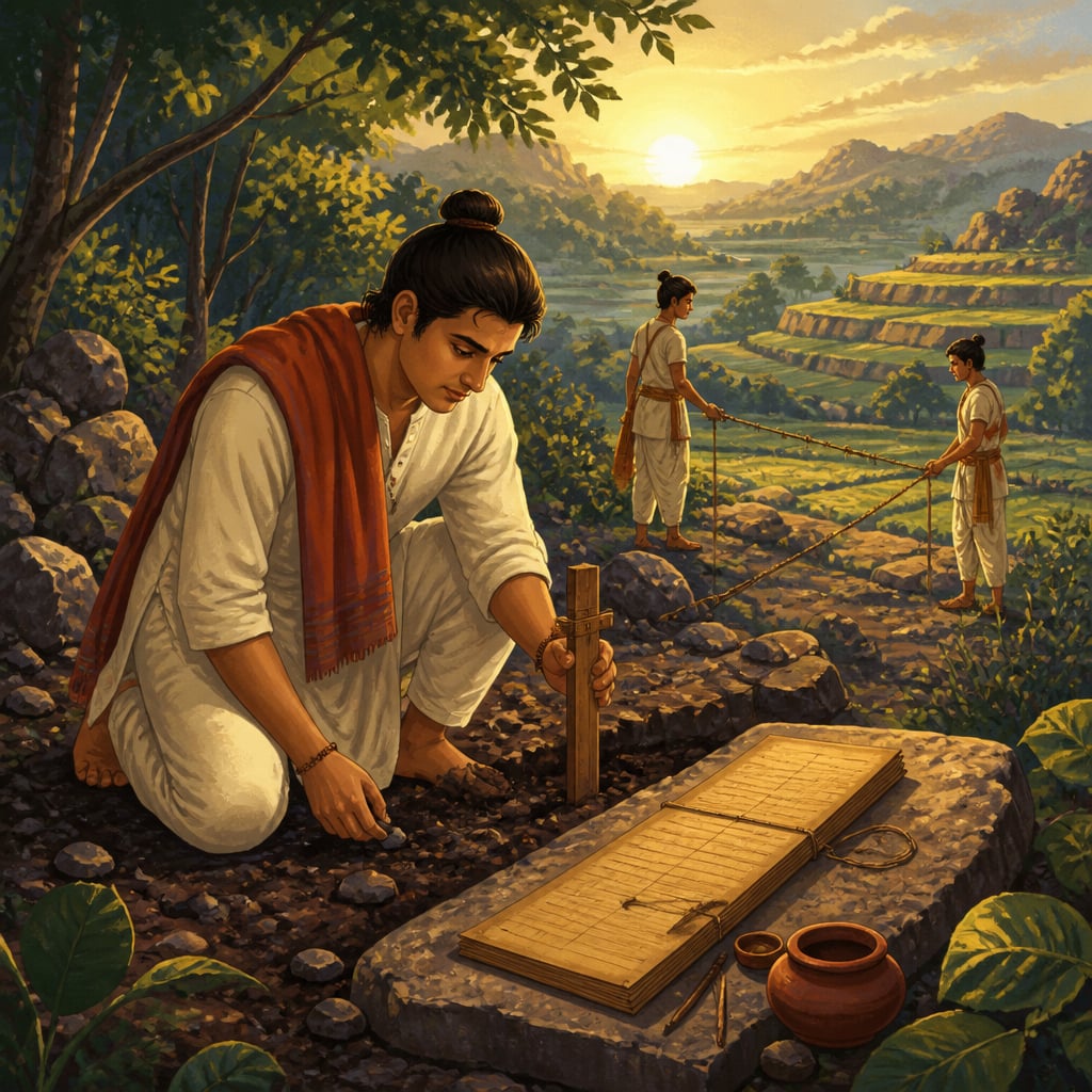
In the spring of 302 BCE, a royal surveying party crossed the Vindhya mountains into newly conquered Dakshinapatha. Devadatta, the chief bhumi-nirupaka (land assessor), led thirty trained surveyors, each carrying measuring rods, water-testing instruments, and leather-bound registers. Their mission: classify every field in the territory so the Mauryan state could tax fairly and cultivate wisely.
Devadatta had studied under Kautilya himself at Takshashila. The master's words echoed in his mind: "Taxation without classification is theft. The king who taxes barren land like fertile land destroys both."
Over the next eighteen months, Devadatta's team would walk every yojana of the new province, testing soil, measuring water tables, noting slopes and drainage. They would create what later empires could only dream of, a complete cadastral survey of productive capacity.
The Science of Land Classification
The Arthashastra's approach to land was revolutionary. While other ancient states simply taxed harvests (taking whatever they could), Kautilya demanded systematic classification before taxation. The logic was economically elegant: if you know what land can produce, you can tax it fairly without destroying the cultivator's incentive.
The Arthashastra prescribes multiple classification criteria:
By Fertility (Urvara-Bheda)
"भूमिं च शस्यसम्पत्तिं च विदित्वा कराणां निवेशः"
"Having ascertained the nature of the land and the yield of crops, taxes should be fixed." , Arthashastra 2.6.3
Devadatta's team classified land into:
- Urvara (fertile), deep soil, good drainage, capable of multiple crops
- Sadharana (medium), adequate for single-crop cultivation
- Anurvara (poor), marginal land suitable only for grazing or forest
By Water Source (Jala-Bheda)
This was perhaps the most sophisticated dimension. The Arthashastra distinguishes:
- Deva-matrka, rain-fed land (dependent on monsoon)
- Nadi-matrka, river-irrigated land (more reliable)
- Kupa-matrka, well-irrigated land (most valuable, independent of rainfall)
- Tadaga-matrka, tank-irrigated land (community-managed water)
Land with assured irrigation commanded higher taxes but also received priority for state investment in drainage and canals.
By Ownership Status
"सीता राष्ट्रियं खण्डस्फुटं च क्षेत्रम्"
"Fields are classified as crown lands, community lands, and private holdings." , Arthashastra 2.24.16
- Sita, crown lands directly managed by the Sitadhyaksha
- Rashtriya, community or village commons
- Swamya, private holdings with hereditary rights
Each category had different tax rates, investment priorities, and cultivation requirements.
The Practical System
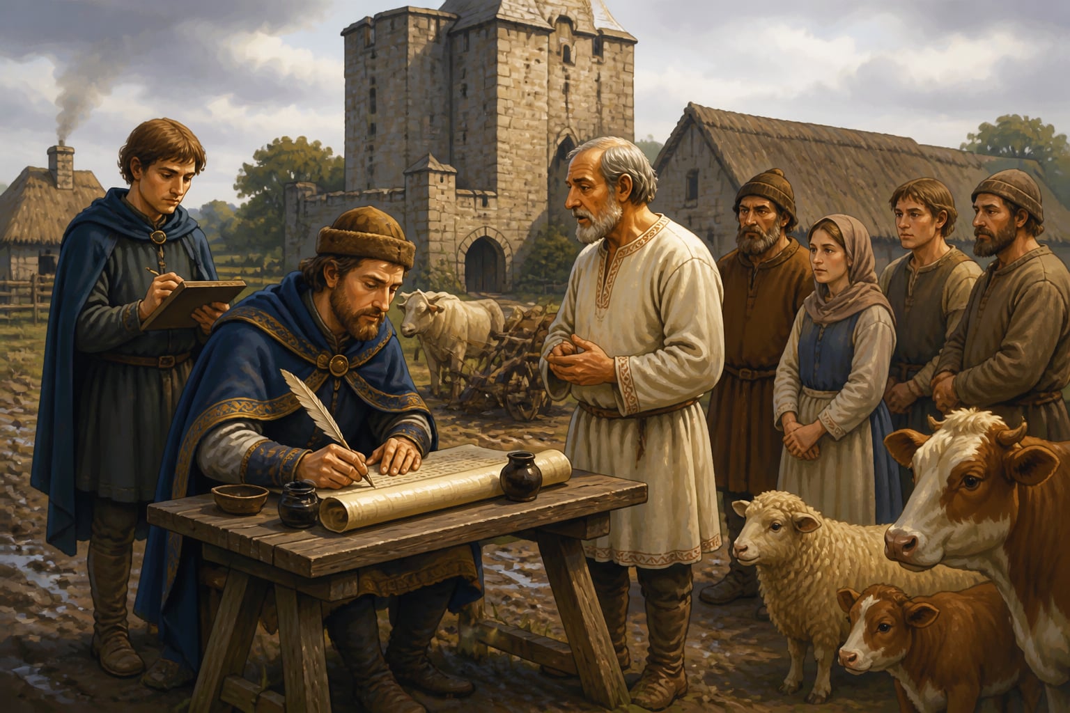
Devadatta didn't just classify, he created a living record. Each village received a bhumi-patra (land register) documenting:
- Boundaries, marked with stone pillars or trees
- Area, measured in nivartana (roughly 4,000 square meters)
- Classification, fertility, water, ownership
- Current use, what crops were planted
- Assessed capacity, what the land could produce under optimal management
- Tax liability, calculated from the above
This wasn't mere bureaucracy. The system enabled:
- Fair taxation, poor land paid less than fertile land
- Investment targeting, irrigation projects went where they'd have maximum impact
- Dispute resolution, clear records prevented boundary conflicts
- Economic planning, the state knew total productive capacity
Global Perspectives on Land Classification
Kautilya's bhumi-vargana was centuries ahead of anything in the Western world.
The Domesday Book (1086 CE) is celebrated as England's first comprehensive land survey, commissioned by William the Conqueror to assess taxable capacity. It classified manors by size, value, and population. Yet this famous achievement came 1,400 years after Kautilya, and lacked the Arthashastra's sophisticated fertility and water-source criteria.
William Petty (1623-1687), the founder of "political arithmetic" (early statistics), conducted Ireland's Down Survey (1656-58), measuring land for Cromwell's redistribution. Petty is celebrated as a pioneer of systematic land assessment, but he was working with concepts Kautilya had codified two millennia earlier.
Robert Torrens (1814-1884) created the Australian land registration system that bears his name, guaranteed title through state registration. The Torrens system is considered revolutionary, but Kautilya's bhumi-patra served a similar function in 300 BCE.
| Innovation | Western Pioneer | Date | Kautilyan Parallel | Arthashastra Date |
|---|---|---|---|---|
| Cadastral survey | Domesday Book | 1086 CE | Bhumi-vargana | 300 BCE |
| Statistical land assessment | William Petty | 1656 CE | Yield-based taxation | 300 BCE |
| Guaranteed land titles | Robert Torrens | 1858 CE | Bhumi-patra records | 300 BCE |
The difference: Kautilya integrated classification with governance. Land records weren't just for taxation, they informed irrigation investment, famine prevention, and settlement policy.
From Bhumi-Patra to Digital India: Modern Resonance
India's land records remained remarkably Kautilyan through the Maurya, Gupta, Mughal, and even early British periods. The patwari system that still operates in rural India descends from the bhumi-nirupaka's tradition.
But decades of neglect left 68% of land records disputed or unclear. The Modi government's response echoes Devadatta's mission:

The Digital India Land Records Modernisation Programme (DILRMP) aims to create what Kautilya would recognize, a complete, accurate, accessible record of every plot. By December 2024:
- 93% of villages have digitized Records of Rights (RoRs)
- 98% of cadastral maps are digitized
- SVAMITVA has mapped 3+ lakh villages using drone technology
The NITI Aayog Land Records team, working with state governments, is essentially recreating bhumi-vargana at scale. Their 2024 Land Titling Framework proposes guaranteed titles, the Torrens system, finally coming to India, but with roots deeper than the West realizes.
What would Devadatta think? The principles are identical: classify accurately, record transparently, enable fair taxation and secure ownership. Only the technology has changed, from measuring rods to drones, from leather registers to blockchain.
The Farmer's Shield
Why does classification matter for the cultivator?
Consider this: without accurate land records, a farmer cannot:
- Access credit, banks require clear collateral
- Receive subsidies, PM-KISAN needs verified landholding data
- Resolve disputes, 66% of civil litigation in India involves land
- Plan succession, unclear records create inheritance conflicts
The Arthashastra understood this. The bhumi-patra wasn't just a tax document, it was the farmer's shield against arbitrary power. When boundaries were marked and records kept, even the king couldn't claim more than his share.
Your Turn: Mapping Your Resources
Kautilya's land classification offers a mental model beyond agriculture. Consider:
What are your "lands"? Every resource you manage, time, money, skills, relationships, has variable "fertility." Some hours are highly productive (morning focus time?); others are marginal (post-lunch slump). Some relationships yield abundant returns; others drain without reciprocation.
Are you classifying before investing? The Sitadhyaksha didn't pour irrigation into barren rock. Are you investing energy where it can actually grow?
Do you have clear records? Devadatta's bhumi-patra prevented disputes. Do you have clear agreements, documented expectations, and transparent accounts in your work and relationships?
In our next lesson, we'll explore Sasya-Niyojana, how the Sitadhyaksha used land classification to plan which crops to plant where, maximizing the empire's agricultural output.
Information asymmetry and market efficiency, the idea that accurate information enables optimal resource allocation.
Friedrich Hayek (1899-1992) argued that markets aggregate distributed information better than central planners. But Kautilya shows that some centralized information, like land classification, is prerequisite for functioning markets.
The Arthashastra combined centralized information (state surveys) with decentralized action (farmer cultivation choices). It solved the information problem Hayek later identified.
66% of all civil litigation in India involves land disputes, the cost of incomplete classification. Clear records could free over 3 crore pending court cases.
Property rights and transaction costs, the Coase theorem insight that clear property rights reduce bargaining costs and enable efficient outcomes.
Ronald Coase (1910-2013) won the Nobel Prize for demonstrating that clear property rights minimize transaction costs. Kautilya implemented this insight operationally 2,300 years earlier.
Key terms
- Bhumi-Vargana
- Land classification, the systematic categorization of agricultural land based on fertility, water access, ownership, and productive capacity for rational taxation and planning.
- Bhumi-Patra
- Land document or register, the official record of a plot's boundaries, classification, ownership, and tax liability maintained by the state.
- Urvara
- Fertile land, soil with high organic content, good drainage, and capacity for multiple cropping cycles per year.
- Deva-matrka
- Rain-fed land, agricultural fields dependent entirely on monsoon rainfall, without irrigation backup. Literally 'mothered by the gods.'
Verses
भूमिं च शस्यसम्पत्तिं च विदित्वा कराणां निवेशः
bhūmiṁ ca śasyasamppattiṁ ca viditvā karāṇāṁ niveśaḥ
Know first the land and what it yields, then fix the tax that justice wields.
This is an early articulation of the economic concept of taxable capacity. Taxing beyond what land can produce destroys incentives and ultimately reduces revenue, a lesson many empires learned too late.
Arthashastra, Book 2, Chapter 6, Verse 3 (R.P. Kangle critical edition)
सीता राष्ट्रियं खण्डस्फुटं च क्षेत्रम्
sītā rāṣṭriyaṁ khaṇḍasphuṭaṁ ca kṣetram
Crown lands, commons, and private plots, each clearly marked and known.
Property rights clarity is foundational to economic development. The Arthashastra's insistence on demarcation prevented the tragedy of the commons and enabled investment in improvements.
Arthashastra, Book 2, Chapter 24, Verse 16 (Patrick Olivelle (2013))
देवमातृकं नद्यायत्तं कूपायत्तं तडागायत्तं च क्षेत्रम्
devamātṛkaṁ nadyāyattaṁ kūpāyattaṁ taḍāgāyattaṁ ca kṣetram
By rain, by river, by well, or by tank, each field marked by its water's source.
Water security is the primary determinant of agricultural value. Well-irrigated land could produce regardless of monsoon, making it both more taxable and more valuable for state investment.
Arthashastra, Book 2, Chapter 1, Verse 22 (L.N. Rangarajan)
Key figures
The Mauryan Bhumi-Nirupaka
Land assessor and surveyor responsible for classifying territory and maintaining land records across the Mauryan Empire
Digital India Land Records Team
NITI Aayog and Ministry of Rural Development officials implementing Digital India Land Records Modernisation Programme (DILRMP) and SVAMITVA
The Domesday Commissioners
Royal commissioners appointed by William the Conqueror to conduct England's first comprehensive land survey
Case studies
PM-SVAMITVA: Drone-Age Bhumi-Vargana
Launched on National Panchayati Raj Day (April 24, 2020), PM-SVAMITVA (Survey of Villages Abadi and Mapping with Improvised Technology in Village Areas) aims to provide clear property rights to every rural household in India. For decades, rural India lacked accurate property records. Abadi areas (residential zones within villages) were especially problematic, colonial surveys focused on agricultural land, leaving homes undocumented. This created a cascade of problems: farmers couldn't use homes as collateral for bank loans, inheritance disputes consumed families for generations, and government schemes couldn't identify beneficiaries. SVAMITVA deploys drone technology to create high-resolution maps of every village, marking individual property boundaries with centimeter-level accuracy. Survey of India processes the imagery, state revenue departments verify ownership, and 'Property Cards' (Sannad/Patta) are issued to households.
Kautilya would recognize SVAMITVA as the technological fulfillment of bhumi-vargana. The Arthashastra prescribed: 1. **Accurate measurement**, Drones provide precision that Devadatta's measuring rods could not 2. **Permanent records**, Digital databases are more durable than palm-leaf registers 3. **Clear ownership**, Property Cards establish rights that courts will recognize 4. **Economic enablement**, Clear titles unlock credit, reduce disputes, enable transactions The dharmic dimension: SVAMITVA prioritizes the marginalized. Rural households that never had documented ownership, often Dalits and Adivasis on village fringes, finally receive state-recognized rights. Classification becomes a tool of justice.
By December 2024, SVAMITVA has achieved: - 3+ lakh villages mapped using drone technology - 1.5+ crore Property Cards distributed to rural households - Rs. 1.25+ lakh crore in property value unlocked for collateral access - 35%+ reduction in rural land disputes in covered areas The scheme targets complete coverage of India's 6.62 lakh villages by 2026. Banks have begun accepting Property Cards as collateral, with SBI launching specific loan products for SVAMITVA beneficiaries.
Technology enables ancient wisdom at scale. Devadatta's surveying party could map a province in 18 months; SVAMITVA can map a district in 18 days. The principle, classify accurately, record transparently, enable ownership, remains Kautilyan. Only the tools have changed.
Property cards distributed under SVAMITVA are already being used as collateral for agricultural loans, unlocking credit that was previously unavailable to rural households. The program addresses a constraint that affects developing nations globally: without clear title documentation, land wealth cannot be converted into productive capital.
Before SVAMITVA, only 30% of rural households could document property ownership for bank loans. In covered villages, this has risen to 75%+.
The Digital Land Records Ecosystem: DILRMP and Soil Health Cards
India's land records crisis emerged from colonial neglect and post-independence fragmentation. The British created records for tax extraction, not farmer empowerment. After 1947, each state developed its own systems, incompatible, incomplete, and often corrupt. By 2008, estimates suggested that 68% of land parcels had disputed or unclear records. The Digital India Land Records Modernisation Programme (DILRMP), launched in 2008 and accelerated after 2014, aims to create 'conclusive titling', where the state guarantees ownership, not merely records claims. The programme has three components: 1. **Computerisation of land records**, Digitizing legacy records 2. **Survey/re-survey**, Creating accurate maps using modern technology 3. **Registration modernisation**, Linking property transactions to updated records Complementing this, the Soil Health Card Scheme (2015) revives the Arthashastra's fertility classification. By testing soil samples and providing farmers with nutrient-specific recommendations, the scheme creates a modern equivalent of urvara/anurvara classification, enabling optimized input use.
Together, DILRMP and Soil Health Cards recreate Kautilya's integrated land management system: **Ownership clarity (Bhumi-Patra)** DILRMP's digitized Records of Rights serve the same function as Mauryan land registers, documenting who owns what, with state authentication. **Fertility classification (Urvara-Bheda)** Soil Health Cards classify land by nutrient status, recommending specific fertilizers. This is precision bhumi-vargana, helping farmers match inputs to actual soil capacity. **Economic enablement** Both programmes aim to increase farmer prosperity: DILRMP by unlocking credit access, Soil Health Cards by reducing input waste (20-30% fertilizer savings reported). The dharmic insight: information is power. When farmers know their land's true capacity and have documented ownership, they can negotiate, plan, and invest with confidence.
By December 2024: **DILRMP Progress:** - 93% of village Records of Rights digitized - 98% of cadastral maps digitized - 7,000+ tehsils connected to central database - Land record access time reduced from weeks to minutes **Soil Health Card Impact:** - 23+ crore cards issued to farmers - 20-30% reduction in fertilizer overuse in adopting farms - Estimated Rs. 10,000+ crore annual savings on unnecessary inputs - Crop yields up 5-8% in regions with high Soil Health Card adoption Challenges persist, record accuracy varies, farmer awareness is uneven, and institutional resistance remains. But the direction is clear: India is digitally recreating its Kautilyan heritage.
Land records and fertility classification are two sides of the same coin, both are about accurate information enabling optimal decisions. DILRMP tells farmers what they own; Soil Health Cards tell them what their land can produce. Together, they form a modern bhumi-vargana system that Devadatta would recognize and applaud.
India's push to integrate land records, soil health data, and crop insurance into a single farmer-facing digital platform represents the next frontier. When a farmer can see what they own, what their soil needs, and what insurance covers, in one place, the information asymmetry that has disadvantaged cultivators for centuries begins to close.
India's soil testing capacity has grown from 45 lakh samples/year (2014) to 3.5 crore samples/year (2024), an 8x increase enabling precision agriculture.
Historical context
Mauryan Empire, 4th-3rd century BCE
The Mauryan period saw India's first systematic cadastral administration. Land was surveyed, classified, and recorded at a scale unprecedented in the ancient world. The empire's revenue, estimated at 25% of agricultural output in good years, depended on accurate classification that distinguished fertile from marginal, irrigated from rain-fed.
No contemporary civilization had comparable land classification. The Persian Empire taxed provinces as units, not individual plots. Greek city-states lacked the bureaucratic capacity for systematic surveys. China's Qin dynasty (221-206 BCE) conducted population counts but not land classification. The Arthashastra's bhumi-vargana was unique.
Archaeological evidence suggests Mauryan land records covered over 5 million hectares, roughly the size of modern Uttar Pradesh's cultivated area.
Land remains India's most contested resource. The principles Kautilya established, classify before taxing, record before claiming, demarcate before disputing, are as relevant today as in 300 BCE. DILRMP and SVAMITVA are not innovations; they are recoveries of a lost administrative wisdom.
Living traditions
India's land administration employs over 4 lakh patwaris and tehsildars, the direct descendants of Kautilya's bhumi-nirupakas. The Digital India Land Records programme aims to transform these traditional record-keepers into digital-first administrators, preserving the function while upgrading the technology.
- Patwari Land Records: Village accountants (patwaris/lekhpals/talatis) maintain the bhumi-patra tradition, recording ownership, transactions, and crop patterns. Their role directly descends from Mauryan land administrators.
- Jamabandi/Record of Rights: Annual updating of land records documenting ownership, tenancy, and agricultural use, a continuous practice tracing to Mauryan bhumi-patra systems.
- Patna Museum Land Records Archive: Houses Mauryan-era administrative artifacts including land measurement instruments
- Any Tehsil Office: Visit your local tehsil to see land records in action, ask to view your family's bhumi-patra (Record of Rights) and understand the classification system
- Tehsil Offices with Traditional Records: Tehsil offices maintain land records that in some cases trace back centuries, physical continuity with administrative traditions that Kautilya codified. Older records demonstrate the persistence of classification systems the Arthashastra prescribed.
- Digital India Land Records Modernization: The digitization of land records represents technological modernization of bhumi-patra, making centuries of documentation accessible online while maintaining the classification principles the Arthashastra established.
Reflection
- Kautilya insisted on classification before taxation, understanding capacity before making demands. In your own life, where have you made demands (of yourself or others) without first understanding actual capacity? How might 'classification', honest assessment, change your expectations and reduce frustration?
- The bhumi-patra documented boundaries to prevent disputes. Think of one relationship or project where boundaries are currently unclear, roles fuzzy, expectations unstated, responsibilities overlapping. What specific 'boundary markers' could you establish this week to create the clarity that prevents conflict?