Nagarayojana: Urban Planning 4,500 Years Ago
Indus Valley grid cities, drainage systems, and standardized construction
Explore the grid-planned cities of the Indus Valley, Mohenjo-daro's sophisticated drainage system, and standardized brick ratios that demonstrate advanced urban planning 4,500 years ago.
Nagarayojana: Urban Planning 4,500 Years Ago
In 1922, when R.D. Banerji began excavating a mound in Sindh that locals called "the mound of the dead," he could not have imagined what lay beneath. As the dust of millennia cleared, what emerged was not a primitive settlement but a sophisticated metropolis, Mohenjo-daro, a city so meticulously planned that modern urban designers study it for inspiration.
This was not an anomaly. Across the Indus Valley civilization, from Harappa in Punjab to Dholavira in Gujarat, from Lothal on the coast to Kalibangan in Rajasthan, cities followed remarkably similar planning principles. Streets ran in precise grid patterns. Houses had private bathrooms. Covered drains ran beneath the streets. Standardized bricks maintained consistent ratios across hundreds of kilometers.
Four and a half thousand years ago, while Mesopotamian cities grew organically around temples and palaces, and Egyptian villages clustered along the Nile, the people of the Indus Valley were building planned cities with amenities that much of the world would not see again until the 19th century.
The Grid System: Order from Chaos
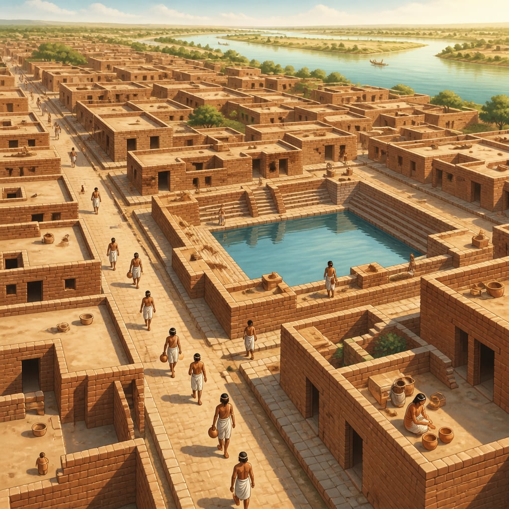
Walk through the ruins of Mohenjo-daro today, and the first thing that strikes you is the geometry. Main streets run perfectly north-south and east-west, intersecting at right angles. Secondary lanes branch off at precise intervals. This is not the organic growth of a village becoming a town, this is deliberate, centralized planning.
The main thoroughfares of Mohenjo-daro were approximately 9 meters (30 feet) wide, broader than many medieval European streets would be three thousand years later. These arterial roads connected the citadel (the elevated western mound) with the lower town where most residents lived.
The grid wasn't merely aesthetic. It served practical purposes:
Drainage: Straight streets with consistent gradients allowed water to flow predictably toward main channels.
Navigation: The regular pattern made the city legible, visitors could orient themselves easily.
Air Circulation: The grid alignment, possibly oriented to prevailing winds, would have aided ventilation in the hot Sindh climate.
Expansion: New blocks could be added systematically without disrupting existing infrastructure.
Harappa, 600 kilometers to the north, followed the same principles. So did Dholavira, over 800 kilometers to the south. This consistency across vast distances suggests either centralized planning authority or a shared engineering tradition so strong that it maintained standards without central enforcement.
The Drainage Revolution

If the grid streets impress, the drainage system astonishes. Every house in Mohenjo-daro had its own bathroom, and many had private wells. Wastewater flowed from houses through covered terracotta pipes into street drains, themselves covered with removable stone slabs for maintenance access.
These street drains connected to larger channels that carried waste to the city's edge. The system required careful gradient management: each section had to slope just enough to maintain flow without causing erosion or backflow.
Archaeologists have found soak pits at intervals along the drains, settling chambers where sediment could accumulate and be periodically cleaned out. This is sophisticated infrastructure engineering, requiring understanding of hydraulics, materials science, and maintenance systems.
The Great Bath of Mohenjo-daro, a 12-meter by 7-meter tank with waterproofed brick walls and bitumen sealant, demonstrates mastery of water containment. Its careful drainage system could empty the entire tank, presumably for cleaning or ritual purposes.
Standardized Bricks: The First Building Code
Perhaps the most remarkable aspect of Indus Valley construction is the standardization of bricks. Across the entire civilization, an area larger than ancient Egypt and Mesopotamia combined, bricks maintained a consistent ratio of 1:2:4 (thickness to width to length).
The most common size was approximately 7 × 14 × 28 centimeters, though larger bricks were used for specific purposes. This standardization was not approximate, archaeological measurements show remarkable consistency.
Consider what this implies. Standardization requires:
Agreement on Standards: Someone had to establish and promulgate the specifications.
Quality Control: Brick-makers had to produce consistent products, requiring molds and oversight.
Trade Networks: Standardized bricks could be manufactured anywhere and used anywhere, enabling specialization and trade.
Regulatory Authority: Some mechanism had to enforce standards across vast distances.
The ratio itself was functionally optimal. The 1:2:4 proportion allows bricks to be laid in multiple configurations, stretcher bond, header bond, English bond, while maintaining structural integrity. It minimizes cutting and waste.
The Two-City Model: Citadel and Lower Town
Most major Indus cities share a distinctive layout: an elevated western "citadel" and a lower eastern residential area. This wasn't mere topography, the citadel mounds were artificially constructed platforms, raised with millions of mud-bricks.
The citadel typically contained public buildings: granaries, assembly halls, ritual baths. The lower town held residential blocks, craft workshops, and markets. This separation suggests functional zoning, an urban planning concept we consider modern.
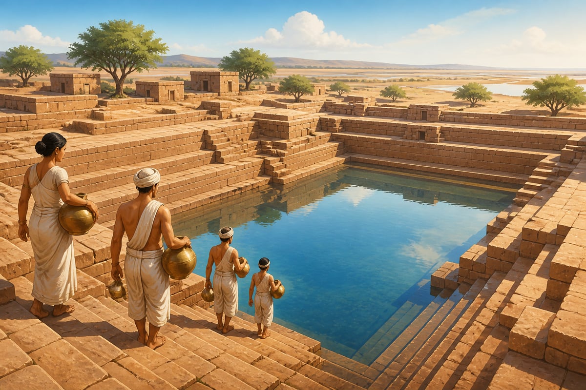
Dholavira, one of the largest Indus sites in India, adds complexity to this model. It had three distinct zones: a citadel, a "middle town," and a "lower town," each with its own fortification walls. The city also featured massive water reservoirs, essential engineering in Gujarat's arid climate.
The Dholavira reservoirs could hold an estimated 10,000 cubic meters of water, collected during monsoons and used throughout the year. Some were cut directly into bedrock, others were built with dressed stone walls. Channels directed rainwater from the citadel into these reservoirs, a comprehensive water harvesting system.
The Mystery of Governance
Despite the obvious central planning, the Indus Valley cities show no clear palaces, no monumental temples, no royal tombs filled with treasure. Unlike Egypt with its pharaohs or Mesopotamia with its kings, the Indus civilization left no obvious markers of individual rulers.
This absence has puzzled archaeologists. How do you coordinate city planning across 800 kilometers without kings? Several theories have emerged:
Merchant Councils: Perhaps trading communities governed collectively, with standardization serving commercial rather than royal purposes.
Priestly Authority: The Great Bath and other possible ritual structures might indicate religious leadership without individual glorification.
Bureaucratic States: Some scholars suggest sophisticated administrative systems that didn't require personality cults.
The answer remains elusive because the Indus script, found on thousands of seals and tablets, remains undeciphered. Until we can read their words, much about Indus society will remain mysterious.
Lessons for Modern Urbanism
The Indus Valley cities collapsed around 1900 BCE, likely due to climate change that disrupted monsoon patterns and the rivers they depended on. But their planning principles have gained new relevance as modern cities face similar challenges.
Water Management: As climate change intensifies droughts and floods, Dholavira's water harvesting systems offer models for sustainable urban water management.
Sanitation Infrastructure: The Indus emphasis on drainage and sewage preceded the 19th-century sanitary revolution by four millennia. Many developing cities today lack infrastructure that Mohenjo-daro had in 2500 BCE.
Standardization: The benefits of standardized building components, interchangeability, quality control, cost reduction, drive modern modular construction movements.
Grid Planning: While organic city growth has its advocates, the legibility and infrastructure efficiency of grid systems remain valuable, especially for new developments.
The Living Legacy
Elements of Indus Valley planning persisted in Indian urbanism. The Arthaśāstra, Kautilya's treatise on statecraft from approximately 300 BCE, prescribes grid planning for new cities. It specifies main roads of standard widths, functional zoning, and drainage requirements, principles visible at Mohenjo-daro two thousand years earlier.
The continuity suggests that Indus planning knowledge didn't entirely vanish with the civilization. It may have been transmitted through craft guilds, administrative traditions, or texts now lost. When Chandragupta Maurya built his capital at Pataliputra, Greek visitors noted its regular streets and impressive infrastructure, echoes, perhaps, of a planning tradition reaching back to the Indus.
Today, as India urbanizes at unprecedented speed, the Indus cities remind us that urban planning is not a modern invention. Our ancestors built cities with covered drains, private bathrooms, and standardized construction materials four and a half millennia ago. The challenge is not discovering these principles but having the will to implement them.
Key figures
R.D. Banerji (Rakhaldas Bandyopadhyay)
1885-1930 CE
Sir John Marshall
1876-1958 CE
Kautilya (Chanakya)
c. 350-283 BCE
Case studies
Dholavira: Water Harvesting in an Arid Land
[2650-1450 BCE] Dholavira, located on Khadir island in Gujarat's Rann of Kutch, receives barely 300mm of annual rainfall. Yet this Indus city sustained a population of thousands for over a millennium. Through an elaborate system of reservoirs that captured every drop of monsoon rain - sixteen reservoirs, some carved into bedrock, storing an estimated 10,000 cubic meters of water.
Dholavira's water system demonstrates sophisticated understanding of hydrology. Channels directed runoff from the citadel into rock-cut reservoirs. Cascading overflow systems connected multiple tanks. The city's location between two seasonal streams was deliberately chosen to maximize water capture.
Singapore, facing similar water constraints on a small island, has developed one of the world's most advanced water management systems. Chennai, after severe droughts, has begun reviving traditional tank systems.
Environmental challenges can drive engineering innovation. Dholavira's water scarcity led to solutions that modern water-stressed cities are now rediscovering.
Chennai, Cape Town, and Sao Paulo have all faced acute water crises in recent years. Dholavira's 16-reservoir system, designed for a region receiving barely 300mm of rain, offers a proven template for decentralized water harvesting that modern cities are now adopting under names like 'sponge city' design.
Ancient Indian stepwells (vav) could store millions of liters of water, serving communities for centuries without mechanical pumps.
Lothal: The World's First Tidal Dock
[2400-1900 BCE] At Lothal in Gujarat, archaeologists discovered a rectangular basin measuring 218 × 37 meters with 4-meter-high walls - identified as a tidal dockyard. Channels connected it to an ancient course of the Sabarmati River. This is the oldest known dock in the world.
Building a tidal dock requires understanding tidal patterns, sedimentation, and hydraulic engineering. The inlet channel was positioned to catch the flood tide while a spillway released excess water. Warehouse structures nearby suggest this was a major trading port.
Modern port cities like Rotterdam and Singapore continue to demonstrate how maritime infrastructure drives economic prosperity. India's Sagarmala project aims to modernize ports.
Trade requirements can drive engineering innovation. Lothal's dock wasn't built for aesthetic reasons but to facilitate commerce - creating infrastructure that outlasted the civilization that built it.
Modern port engineering still grapples with tidal management, sediment control, and ship access. Rotterdam's Europoort and Singapore's Tuas Terminal solve the same hydraulic engineering problems that Lothal's builders addressed 4,000 years ago, just at larger scale with mechanical assistance.
37 meters - referenced in the context of Lothal: The World's First Tidal Dock.
From Mohenjo-daro to Chandigarh: The Grid Persists
When India needed a new capital for Punjab after Partition, Le Corbusier designed Chandigarh on grid principles - sectors organized around a hierarchy of roads (V1-V7), with systematic separation of functions. While Corbusier's modernist vision drew on European planning theory, the underlying grid logic would have been familiar to Mohenjo-daro's planners.
Chandigarh's sector-based grid enables efficient infrastructure provision, clear wayfinding, and systematic expansion - the same benefits Mohenjo-daro's grid offered. Both cities prioritize functionality over organic growth.
New smart cities like Amaravati and GIFT City incorporate grid planning with modern technology. The principles are ancient; the implementation evolves.
Planning principles transcend specific civilizations. The grid, discovered independently by multiple cultures, persists because it solves real urban problems effectively.
Urban planners continue to debate grid versus organic city layouts. The grid pattern appears in ancient Mohenjo-daro, Roman camps, Manhattan, and modern smart city proposals like Dholera in Gujarat. Its persistence across 5,000 years and dozens of civilizations proves it solves real problems of navigation, infrastructure routing, and land division.
Ancient Indian stepwells (vav) could store millions of liters of water, serving communities for centuries without mechanical pumps.
Historical context
Indus Valley Civilization (3300-1300 BCE)
Living traditions
The Indus cities' legacy lives in unexpected places. The standardized brick ratios persisted in Indian construction for millennia. Modern Indian cities, as they grapple with sanitation and drainage challenges, are rediscovering that their ancestors solved these problems four thousand years ago. The grid planning of Chandigarh, Gandhinagar, and newer smart cities continues a tradition far older than Le Corbusier.
- Dholavira: One of the largest Indus sites in India, remarkable for its water reservoirs, three-part city structure, and the famous Dholavira Signboard. UNESCO World Heritage Site since 2021.
- Lothal: Indus trading port with the world's oldest known dock, bead-making workshop, and on-site museum with artifacts.
- National Museum, New Delhi: Houses major Indus Valley artifacts including the famous Dancing Girl of Mohenjo-daro, Priest King statue, seals, weights, and everyday objects.
Reflection
- The Indus civilization achieved sophisticated urban infrastructure without leaving evidence of kings, temples, or armies. What might this suggest about alternative ways of organizing complex societies?
- Many modern Indian cities struggle with drainage and sanitation that Mohenjo-daro solved 4,500 years ago. What factors prevent us from implementing solutions we know to work?
- The Indus civilization standardized bricks across 800 kilometers without modern communication technology. How did they achieve this, and what can it teach us about maintaining standards in distributed systems?