Vanijpatha: Developing Trade Routes
Infrastructure as Strategic Statecraft
Kautilya understood that trade routes aren't discovered, they're built. From the Mauryan Uttarapatha to modern PM Gati Shakti, learn why infrastructure investment is the foundation of economic power, and how India is rebuilding its ancient trade networks.
The Road That Built an Empire
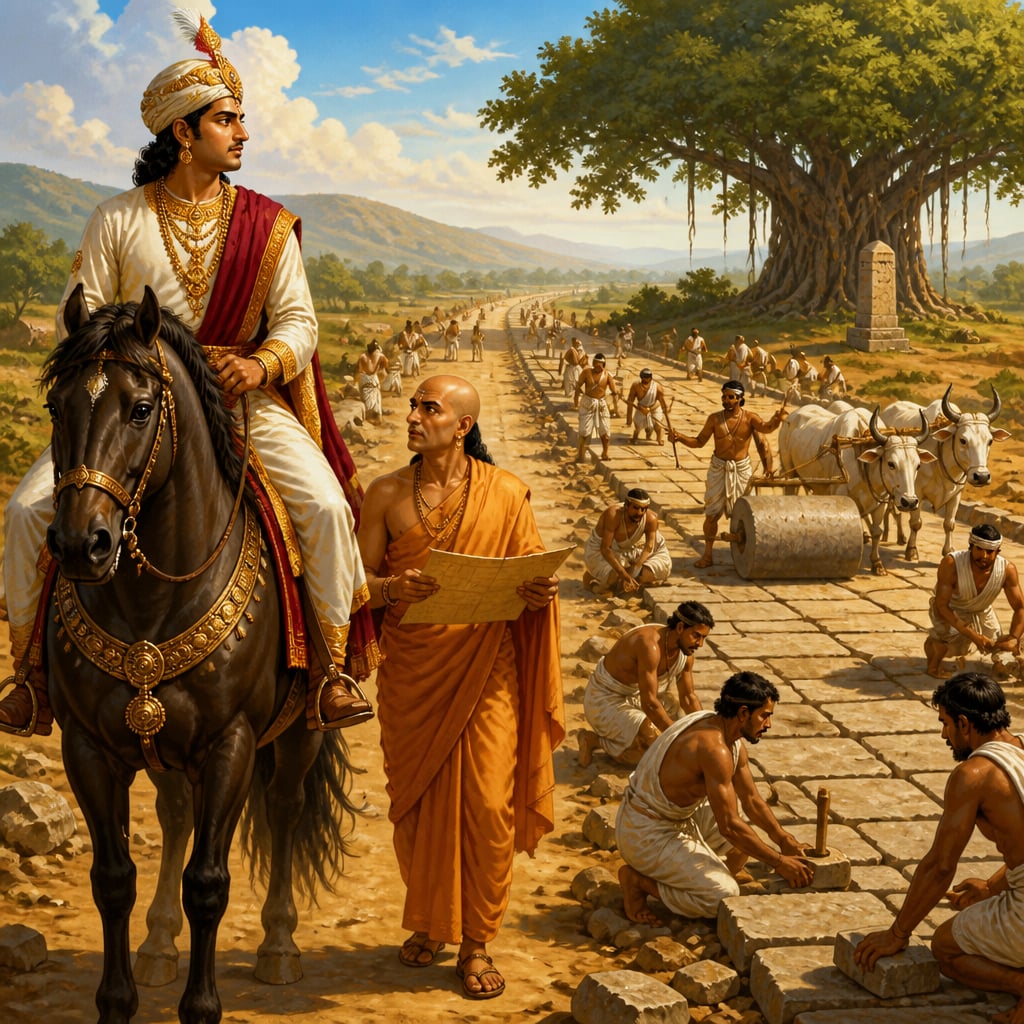
In 320 BCE, Chandragupta Maurya surveyed the royal road from Taxila to Pataliputra. The journey took forty days. Bandits lurked in every forest. Ferries ran when ferryman felt like working. Merchants who made it paid premium prices; many didn't make it at all.
Fifty years later, under Ashoka, the same journey took twenty days. The road was stone-paved where it crossed major rivers. Rest houses (sarais) stood every twenty kilometers, with wells, grain stores, and garrison protection. Standardized ferries operated on schedule. Trade volumes had tripled.
The difference wasn't geography, the mountains and rivers hadn't moved. The difference was infrastructure: deliberate, state-funded investment in the physical foundations of commerce.
This was not mere road-building. This was strategic geography creation.
The Architecture of Ancient Trade Routes
Kautilya devoted significant attention to vanijpatha, trade routes, in the Arthashastra. His approach was systematic: identify chokepoints, invest in enabling infrastructure, and treat route development as strategic statecraft.
वाणिज्यपथमध्यक्षः राजमार्गं निर्मापयेत्। यथा कोशवृद्धिः स्यात् तथा मार्गान् कल्पयेत्॥
"The superintendent of trade routes shall construct the royal highways. He shall develop roads such that the treasury grows." , Arthashastra 2.1.20
The Arthashastra specifies infrastructure requirements:
Road Standards:
- Royal highways (rajamarga): 10 dhanus (60 feet) wide
- Provincial roads: 4 dhanus wide
- Village roads: 2 dhanus wide
- Elephant paths: separate, stronger construction

Supporting Infrastructure:
- Rest houses every krosa (approximately 3 km)
- Wells at regular intervals
- Shade trees planted along routes
- Garrison posts at strategic points
- Ferries at river crossings (state-operated)
Maintenance Requirements:
- Regular repair schedules
- Fines for obstructing roads
- Officials responsible for specific segments
- Revenue allocated to route maintenance
The Economics of Connectivity
Kautilya understood what modern economists call 'network effects': the value of a route increases exponentially with what it connects.
एकमार्गद्वयोर्भेदे स्थलजलपथयोः मध्ये। जलपथं श्रेयस्करं विद्यात् स्थलपथात्॥
"Between a land route and a water route, the water route is more beneficial, it carries more with less effort." , Arthashastra 7.12.25
This preference for water routes reflects sophisticated cost-benefit analysis:
| Route Type | Cost per Load | Speed | Capacity | Risk |
|---|---|---|---|---|
| Land (bullock cart) | High | Slow | Low | Moderate |
| River | Low | Moderate | High | Low |
| Coastal maritime | Very low | Fast | Very high | Higher |
The Mauryan investment portfolio reflected this analysis: while they built extensive roads, they also dredged rivers, constructed ports, and maintained naval patrols on major waterways.
Global Perspectives: Eisenhower and the Interstate Vision
Dwight D. Eisenhower (1890-1969) understood infrastructure as strategic power, learned from an unlikely source.
In 1919, young Lieutenant Colonel Eisenhower joined a military convoy crossing the United States. The journey from Washington D.C. to San Francisco took 62 days. Roads were unpaved, bridges collapsed, vehicles broke down constantly. Eisenhower never forgot.
Decades later, as Supreme Allied Commander in Europe, Eisenhower witnessed Hitler's Autobahn, high-speed highways that enabled rapid military movement. The connection crystallized: infrastructure is power.
In 1956, President Eisenhower signed the Federal-Aid Highway Act, creating the Interstate Highway System. The official rationale was national defense, highways for evacuating cities during nuclear attack. The real impact was economic transformation:
- 48,000 miles of high-speed roads
- Enabled trucking industry explosion
- Created suburban America
- Unified national market
- Estimated return: $6 for every $1 invested
Kautilya and Eisenhower reached the same conclusion: infrastructure investment returns compound over generations. The upfront cost is visible; the returns are distributed across the entire economy, forever.
| Aspect | Mauryan Highways | US Interstates |
|---|---|---|
| Strategic purpose | Enable trade + military movement | Enable trade + military movement |
| Funding model | State treasury | Federal fuel tax |
| Design principle | Connect major cities, bypass obstacles | Connect major cities, bypass obstacles |
| Supporting infrastructure | Rest houses, wells, garrisons | Rest stops, fuel stations, highway patrol |
| Economic impact | Enabled continental trade | Enabled national market |
The parallels aren't coincidental, they reflect the underlying logic of infrastructure as strategic investment.
Modern Resonance: Amitabh Kant and India's Infrastructure Renaissance
Amitabh Kant, CEO of NITI Aayog (2016-2022) and G20 Sherpa (2022-present), has been the architect of India's infrastructure revival. His approach is explicitly Kautilyan: infrastructure as the foundation of economic power.
Kant's mantra: "Infrastructure is not an expense, it's an investment that pays returns for centuries."
Under his influence, India has pursued the most ambitious infrastructure program in its post-independence history:
PM Gati Shakti (2021) A ₹100 lakh crore integrated infrastructure masterplan, Gati Shakti coordinates 16 ministries on a single digital platform. No more roads ending at state boundaries, no more ports without connecting highways. The Mauryan principle of integrated route development, enabled by digital mapping.
Bharatmala (2017) A ₹10 lakh crore highway development program, Bharatmala focuses on economic corridors, border roads, and coastal connectivity. Target: 65,000 km of new and upgraded highways connecting major industrial zones.
Sagarmala (2015) Port-led development investing ₹8 lakh crore in coastal infrastructure. India's 7,500 km coastline had been underutilized; Sagarmala aims to reduce logistics costs by enabling coastal shipping, exactly what Kautilya recommended: "the water route is more beneficial."
IMEC (2023) The India-Middle East-Europe Corridor, announced at the G20 Summit that Kant helped orchestrate, creates a rail-and-sea route connecting India to Europe via UAE, Saudi Arabia, and Israel. This is strategic geography creation at continental scale.
The Vanijpatha Principles
Kautilya's route development principles remain applicable:
1. Integration Over Isolation Routes must connect to each other. A highway without port access, a port without road connections, these are wasted investments. Gati Shakti's digital integration addresses exactly this.
2. Capacity Precedes Demand Build infrastructure before trade saturates existing routes. Waiting for congestion means losing opportunities. The Mauryas built roads to enable trade that didn't yet exist.
3. Water Routes Where Possible Sagarmala reflects Kautilya's preference. Coastal shipping uses 1/6th the fuel of road transport per ton-kilometer. India's under-investment in coastal infrastructure was an unforced error.
4. Strategic Routes First Prioritize routes with maximum strategic impact, border connectivity, export corridors, links to allies. Bharatmala's focus on border roads and Chabahar's strategic importance reflect this logic.
5. Maintenance Is Non-Negotiable Kautilya specified maintenance obligations and fines for road damage. Modern India's highway maintenance (through toll revenue and NHAI) implements this principle.
Your Turn: Building Your Own Vanijpatha
Infrastructure thinking applies at personal scale:
- Career routes: What connections enable your professional movement? Investing in skills, relationships, and credentials is personal infrastructure, it compounds.
- Information routes: How do ideas reach you? Curating high-quality information sources is building your intellectual vanijpatha.
- Financial routes: What channels move your money to opportunities? Bank accounts, investment platforms, networks that surface deals, these are your financial infrastructure.
- Relationship routes: Strong connections enable everything else. Like Kautilya's rest houses, regular relationship maintenance keeps routes open.
The merchant who traveled the Uttarapatha prospered because the state had invested in roads, rest houses, and security. Your prosperity similarly depends on the routes you build, and maintain.
In Lesson 5, we protect the merchants. The Vanij-Raksha, Merchant Protection and Rights, reveals how Kautilya ensured that those who used the routes were protected. Infrastructure without security is incomplete.
Modern project appraisal (NPV, IRR, cost-benefit ratios) applies exactly this framework. The World Bank's infrastructure investment guidelines require economic return calculations before funding approval.
Kautilya's 'koshavriddhih' criterion is more sophisticated than mere return calculations, it considers treasury growth, which includes indirect effects (trade enabled, taxes generated, military mobility) that narrow financial returns miss.
The US Interstate System returned $6 for every $1 invested over 50 years. India's National Highways generated economic returns of 8-10% annually. Infrastructure investment compounds.
Modern logistics confirms Kautilya's hierarchy: maritime shipping costs $0.02/ton-km, rail $0.05/ton-km, truck $0.15/ton-km. Water transport is 6-7x more efficient than road for bulk goods.
India's coastline (7,500 km) and rivers were historically underutilized for commerce. Sagarmala and National Waterways projects finally implement Kautilya's preference, centuries after he recommended it.
Coastal shipping share of India's freight: 6% (2015) → target 12% (2025). Each percentage point shift saves billions in logistics costs, Kautilya's jalapatha economics, quantified.
Key terms
- Vāṇijyapatha
- Trade route; the physical and institutional infrastructure enabling commerce between locations
- Rājamārga
- Royal highway; the highest-grade road in the infrastructure hierarchy, directly maintained by the state
- Satra
- Rest house; a state-maintained facility providing shelter, water, and supplies for travelers
- Jalapatha
- Water route; river or maritime transport pathways, preferred for bulk cargo
Verses
वाणिज्यपथमध्यक्षः राजमार्गं निर्मापयेत्। यथा कोशवृद्धिः स्यात् तथा मार्गान् कल्पयेत्॥
vāṇijyapathamadhyakṣaḥ rājamārgaṁ nirmāpayet | yathā kośavṛddhiḥ syāt tathā mārgān kalpayet ||
The superintendent of trade routes shall construct the royal highways. He shall develop roads such that the treasury grows.
This anticipates modern cost-benefit analysis for infrastructure. The question isn't 'should we build a road?' but 'which road generates maximum economic returns?' Modern project appraisal methodology applies exactly this framework.
Arthashastra, Book 2, Chapter 1, Verse 20 (R.P. Kangle (1965))
एकमार्गद्वयोर्भेदे स्थलजलपथयोः मध्ये। जलपथं श्रेयस्करं विद्यात् स्थलपथात्॥
ekamārgadvayorbhede sthalajalapatthayoḥ madhye | jalapathaṁ śreyaskaraṁ vidyāt sthalapathāt ||
Between a land route and a water route, the water route is more beneficial, it carries more with less effort.
Modern logistics confirms this hierarchy: maritime shipping costs 1/6th of road transport per ton-km. India's under-investment in coastal shipping (now addressed by Sagarmala) represented a departure from this ancient wisdom.
Arthashastra, Book 7, Chapter 12, Verse 25 (L.N. Rangarajan (1992))
राजमार्गस्य विस्तारः दशधनुषः स्यात्। प्रान्तयोः वृक्षारोपणं कुर्यात्। क्रोशे क्रोशे सत्रं निर्मापयेत्॥
rājamārgasya vistāraḥ daśadhanuṣaḥ syāt | prāntayoḥ vṛkṣāropaṇaṁ kuryāt | krośe krośe satraṁ nirmāpayet ||
The royal highway shall be sixty feet wide. Trees shall be planted on both sides. Rest houses shall be built every three kilometers.
Modern highway standards (lane widths, shoulder requirements, rest area spacing) follow the same logic. Infrastructure without specifications degrades; specifications enable quality assurance and maintenance accountability.
Arthashastra, Book 2, Chapter 4, Verse 8-10 (Patrick Olivelle (2013))
Key figures
Kautilya (Chanakya)
Author of Arthashastra; Chief Minister to Chandragupta Maurya
Amitabh Kant
G20 Sherpa (2022-present); former CEO of NITI Aayog (2016-2022); former DPIIT Secretary
Dwight D. Eisenhower
34th President of the United States (1953-1961); Supreme Allied Commander in WWII; creator of the Interstate Highway System
Case studies
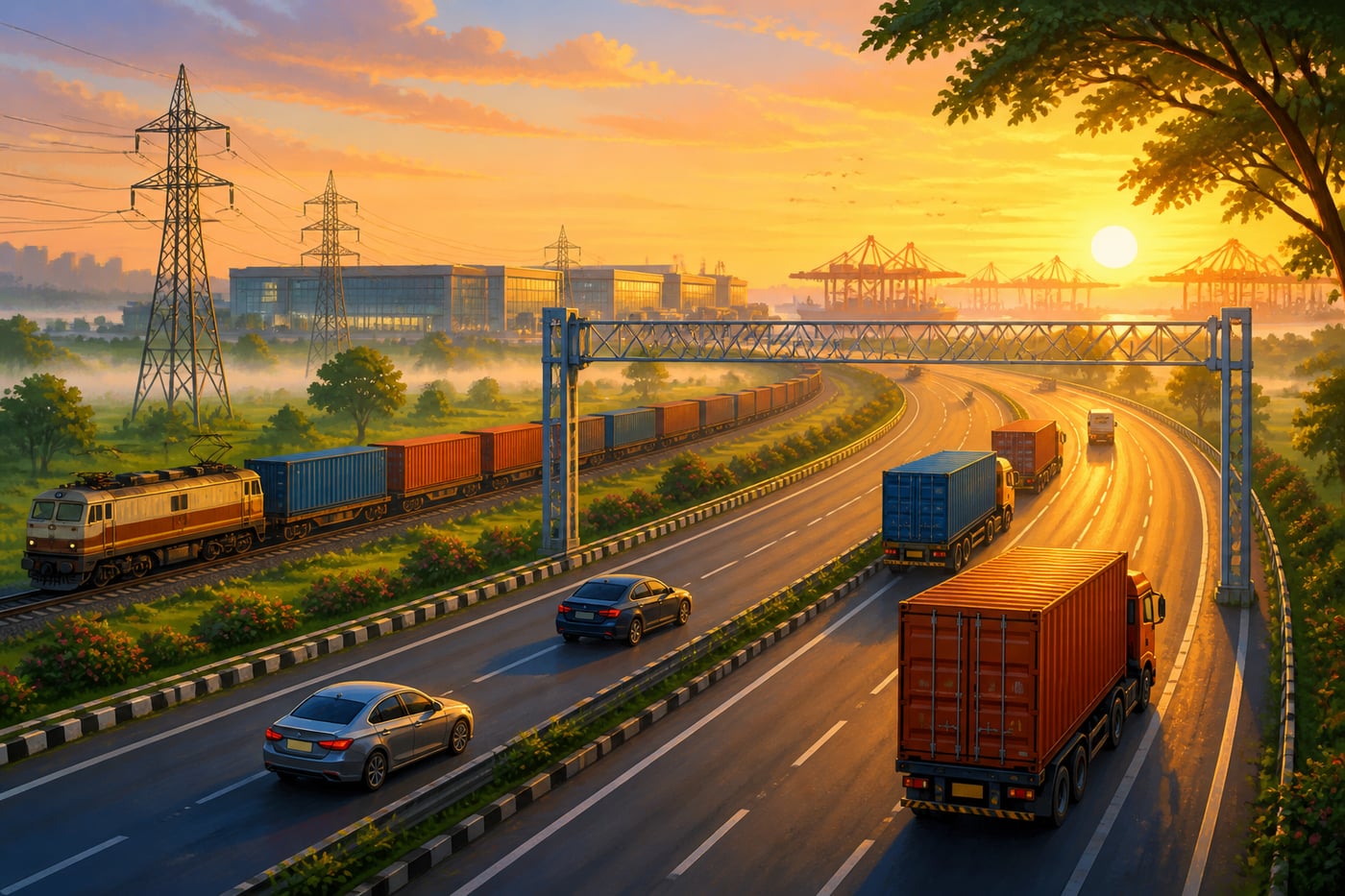
India's Infrastructure Trinity: Gati Shakti, Bharatmala, Sagarmala
In 2014, India's infrastructure was fragmented. Highways ended at state borders. Ports lacked road connections. Rail lines bypassed industrial zones. The logistics cost burden, 14% of GDP, was nearly double that of developed nations. Goods that should take three days took ten. The problem wasn't just underinvestment, it was lack of integration. Roads were built without considering ports. Ports were developed without rail links. Industrial corridors existed on paper but lacked physical connectivity. The government launched three coordinated initiatives: **Sagarmala (2015)**: ₹8 lakh crore for port-led development. Modernize major ports, develop minor ports, create coastal economic zones, and, critically, connect ports to hinterlands via rail and road. **Bharatmala (2017)**: ₹10 lakh crore for economic corridors, border roads, and coastal highways. Not just more roads but strategic roads connecting industrial zones, ports, and borders. **PM Gati Shakti (2021)**: ₹100 lakh crore integrated masterplan. A digital platform coordinates 16 ministries, ensuring that road investments consider rail links, port developments include highway connections, and industrial zones get multimodal access.
Kautilya's vanijpatha principles are evident: 1. **Integration**: Gati Shakti's single platform ensures that infrastructure investments connect, exactly what Kautilya mandated when he specified that trade routes serve treasury growth, not just exist. 2. **Water Route Priority**: Sagarmala implements Kautilya's preference for jalapatha. Coastal shipping costs 1/6th of road transport; India's coastline was the underutilized asset. 3. **Strategic Routes First**: Bharatmala prioritizes economic corridors and border roads, routes with maximum strategic impact, not just political visibility. 4. **Specifications and Standards**: All three programs specify measurable targets (lane widths, port capacity, rail speed), exactly the kind of concrete standards Kautilya mandated. 5. **Maintenance Accountability**: NHAI's toll-operate-transfer model ensures maintenance responsibility, Kautilya's insight that construction without maintenance is wasted investment.
Results by 2024: - **National highways**: 145,000 km (up from 91,000 km in 2014) - **Expressways**: 4,000+ km operational (nearly zero in 2014) - **Port capacity**: 2,500 MTPA (up from 1,500 MTPA) - **Logistics cost**: 13% of GDP (down from 14%, target 10%) - **Gati Shakti projects**: 160,000+ mapped and coordinated - **Dedicated Freight Corridors**: Eastern and Western DFCs operational The infrastructure trinity created what Kautilya prescribed: integrated trade routes designed for treasury growth. The 1% GDP reduction in logistics costs equals savings of ₹2+ lakh crore annually, returns that compound indefinitely.
Infrastructure investment succeeds when integrated across modes (road, rail, port), prioritized by economic returns, and designed with maintenance accountability. India's infrastructure trinity implements Kautilyan principles at national scale.
India's National Logistics Policy targets reducing logistics costs to 8% of GDP by 2030, which would save over Rs. 7 lakh crore annually. The Gati Shakti platform's integrated planning approach is being studied by Brazil and Indonesia as a model for coordinating infrastructure across large federal systems.
Each 1% reduction in logistics costs saves ₹2+ lakh crore annually. Target: 10% by 2030. Kautilya's koshavriddhih criterion, invest for treasury growth, proven at continental scale.
IMEC: The 21st-Century Spice Route
On September 9, 2023, at the G20 Summit in New Delhi, leaders announced the India-Middle East-Europe Economic Corridor (IMEC). The corridor would connect India to Europe via UAE, Saudi Arabia, Jordan, and Israel, rail lines, ports, and digital infrastructure creating a new trade route. The strategic context was clear: China's Belt and Road Initiative had been reshaping Eurasian trade geography since 2013. Traditional routes through Suez were congested and vulnerable. India needed alternatives that bypassed both Chinese-influenced routes and Pakistan. IMEC creates a multimodal corridor: - Sea route: India to UAE/Saudi Arabia - Rail route: Through Arabian Peninsula and Levant to Mediterranean - Sea route: Mediterranean to Europe Estimated benefits: 40% faster than Suez route for India-Europe trade, with added resilience from route diversification.
IMEC embodies Kautilya's strategic infrastructure thinking: 1. **Trade Routes as Strategic Assets**: Kautilya understood that controlling trade routes means controlling commerce. IMEC creates a route India can influence, unlike Suez (distant) or land routes through China's sphere. 2. **Alliance Through Trade**: 'An alliance through trade is superior to military alliance.' IMEC connects India with Middle Eastern and European economies, creating interdependence that strengthens diplomatic ties. 3. **Alternative Routes**: Kautilya recommended developing multiple routes to reduce dependence on any single path. IMEC diversifies India's Europe trade from Suez-dependence. 4. **Water + Land Integration**: IMEC combines sea routes (India-Gulf, Mediterranean-Europe) with land routes (Gulf-Mediterranean rail), the integrated approach Kautilya prescribed. 5. **Strategic Geography Creation**: The corridor doesn't just use existing geography, it creates new trade geography. Strategic infrastructure changes what's possible.
IMEC status and projections (2024-2030): - **MoU signed**: September 2023 at G20 New Delhi - **Partners**: India, UAE, Saudi Arabia, Jordan, Israel, EU, US - **Route time**: 40% faster than Suez for India-Europe trade - **Investment**: Estimated $20+ billion across corridor - **Strategic benefit**: Reduces India's Suez dependence, bypasses China-influenced routes - **Energy component**: Clean energy grid alongside trade infrastructure IMEC represents infrastructure as foreign policy, Kautilya's mandala theory implemented through physical connectivity. By creating trade routes with strategic partners, India builds alliances more durable than military pacts.
Strategic infrastructure creates strategic geography. IMEC demonstrates that in the 21st century, as in Kautilya's time, controlling trade routes means shaping economic and political destiny. Infrastructure investment is geopolitical investment.
IMEC gained urgency after Houthi attacks disrupted Red Sea shipping in 2023-24, demonstrating that alternative trade routes are strategic necessities, not theoretical luxuries. For India, controlling a trade corridor to Europe reduces dependence on chokepoints that adversaries can threaten.
India-Europe trade: $120 billion annually. IMEC's 40% time savings plus resilience benefits could capture significant share from Suez route. Strategic route development, Kautilyan scale.
Historical context
Mauryan Empire (322-185 BCE)
The Mauryan road network was revolutionary: the first subcontinental infrastructure enabling trade from the Hindu Kush to the Bay of Bengal. Previous kingdoms had local roads; the Mauryas built a system. This infrastructure outlasted the empire, serving trade for centuries after Mauryan decline.
Contemporary infrastructure: Rome's roads (comparable quality, different scale), Achaemenid royal road (predecessor to Mauryan Uttarapatha), Chinese roads (less systematic than Qin dynasty's later efforts). The Mauryan network was among the most extensive of its era.
The Uttarapatha: approximately 2,000 km from Taxila to Pataliputra. Travel time: 40 days pre-Mauryan, 20 days post-infrastructure. The investment halved transit time, compounding returns over centuries.
Mauryan infrastructure created the physical foundation for Indian Ocean trade dominance that lasted 1,500 years. The routes Kautilya's system built continued serving commerce through Gupta, Chola, and Mughal eras. Infrastructure investment compounds across generations.
Living traditions
India's infrastructure programs explicitly cite historical precedent. PM Modi has invoked ancient trade routes when discussing IMEC. Sagarmala references historical port cities. The connection isn't just rhetorical, modern corridors often follow routes that have served trade for millennia.
- PM Gati Shakti Portal: The digital platform integrating 16 ministries' infrastructure plans. Projects are mapped, coordinated, and monitored in real-time, ensuring the integration Kautilya mandated.
- National Highways Authority of India (NHAI): The agency responsible for national highway development and maintenance. Toll collection funds maintenance; performance metrics track quality, accountability structures for infrastructure.
- Grand Trunk Road (GT Road) Heritage: The modern GT Road follows the ancient Uttarapatha route from Peshawar (now Pakistan) through Delhi to Kolkata. While the highway is modern, the route is ancient, the same path merchants traveled in Kautilya's time.
- Lothal, Gujarat: The world's earliest known dock, built by the Indus Valley civilization around 2400 BCE. Lothal demonstrates India's ancient understanding of port infrastructure, artificial harbors enabling maritime trade.
- Dwarkadhish Temple: Located at the western end of ancient trade routes, Dwarka connected maritime and overland commerce. The temple's prosperity historically depended on trade route maintenance, pilgrims and traders alike benefited from infrastructure that served both sacred and commercial journeys.
- Somnath Temple: Somnath's repeated destruction and reconstruction symbolizes infrastructure resilience. Its coastal location on trade routes made it wealthy, and a target. Modern infrastructure programs like Sagarmala aim to restore India's maritime infrastructure tradition that Somnath represents.
Reflection
- Kautilya's infrastructure investments took decades to build but served trade for centuries. Modern democracies often underinvest in infrastructure because returns come after elections. How should societies balance short-term political cycles with long-term infrastructure needs? What governance structures enable long-horizon thinking?
- Kautilya understood that infrastructure investment compounds over generations. What 'infrastructure' investments in your own life, skills, relationships, systems, habits, will compound over years and decades? Which short-term expenses are actually long-term investments?