Adam's Bridge and the Greater Pilgrimage
The bridge between myth and geography
Explore the geological mystery of Rama Setu (Adam's Bridge) - the chain of limestone shoals connecting India to Sri Lanka. Examine the NASA imagery, the scientific debates, the ghost town of Dhanushkodi, Gandhamadana Parvatam with Hanuman's footprint, the Pamban Bridge, and the complete pilgrimage circuit of Rameswaram.
Where Myth Meets Geography
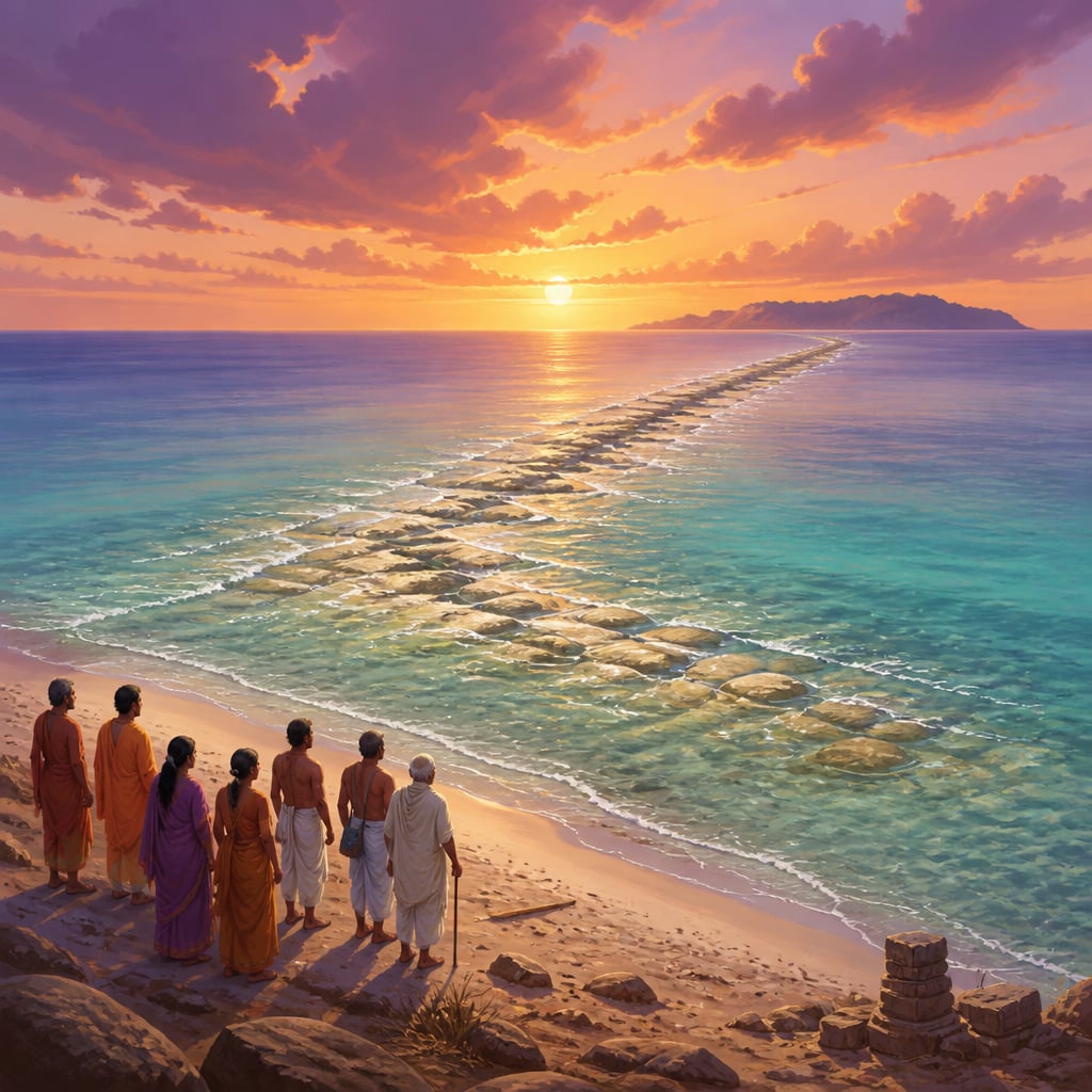
Stand at Dhanushkodi, the eastern tip of Rameswaram island, and look across the shallow waters toward Sri Lanka. On a clear day, you might almost imagine you could walk there. Indeed, there are shoals just beneath the surface stretching toward the island nation, a chain of limestone and sand that connects India to Sri Lanka across 48 kilometers of sea.
This is Rama Setu. Adam's Bridge. One of the most remarkable geographical features in South Asia, and one of the most contested. Is it a natural formation, created by geology over millennia? Or is it, as millions of Hindus believe, the very bridge that Rama's army built to reach Lanka?
The answer you accept depends largely on whether you trust geology or tradition, and perhaps on whether you believe those two must always conflict.
The Physical Reality
The Rama Setu is a chain of limestone shoals (shallow underwater ridges) stretching from Dhanushkodi in India to Talaimannar in Sri Lanka. The formation has some unusual characteristics:
Length: Approximately 48 kilometers from end to end, though the exact measurement depends on where one considers the formation to begin and end.
Depth: The shoals lie in remarkably shallow water, in some places just 1-3 meters below the surface. Ships cannot pass without dredging.
Composition: The formation consists of limestone, coral, and sand, sitting atop marine sand. The materials are not unusual, but their arrangement is.
Alignment: The shoals run in an unusually straight line, given that they are supposedly natural formations. This regularity has fueled speculation about human involvement.
Age: Geological estimates vary widely, from 7,000 to 18,000 years old. The dating depends on methodology and which layers are being measured.
The NASA Images
In 2002, NASA released satellite images of the Palk Strait (the body of water between India and Sri Lanka). These images clearly showed the underwater ridge formation connecting the two landmasses.
The images went viral, with many interpreting them as "proof" of the Ramayana's historical accuracy. NASA subsequently clarified that their images showed a naturally occurring formation and that the organization had no position on the Ramayana's historicity.
But the images continued to circulate, annotated with Ramayana references. For believers, the images confirmed what faith had always known. For skeptics, the images showed an interesting geological formation being misinterpreted. For scientists, the images raised questions worth investigating without predetermined conclusions.
The debate continues. What cannot be debated is that the formation exists, clearly visible from space, connecting India to Sri Lanka along the path the Ramayana describes.
The Ramayana Account
According to the Ramayana, after Rama worshipped Shiva at what would become Rameswaram, the challenge remained: how to transport a massive army across the sea to Lanka?
Vibhishana, Ravana's brother who had defected to Rama's side, suggested seeking the ocean god Varuna's help. Rama fasted and prayed on the shore for three days. When Varuna did not appear, Rama raised his bow in anger, threatening to dry up the ocean with celestial weapons.
Varuna appeared and offered a solution: he would hold the waters steady while a bridge was constructed. The ocean would support whatever was built upon it.
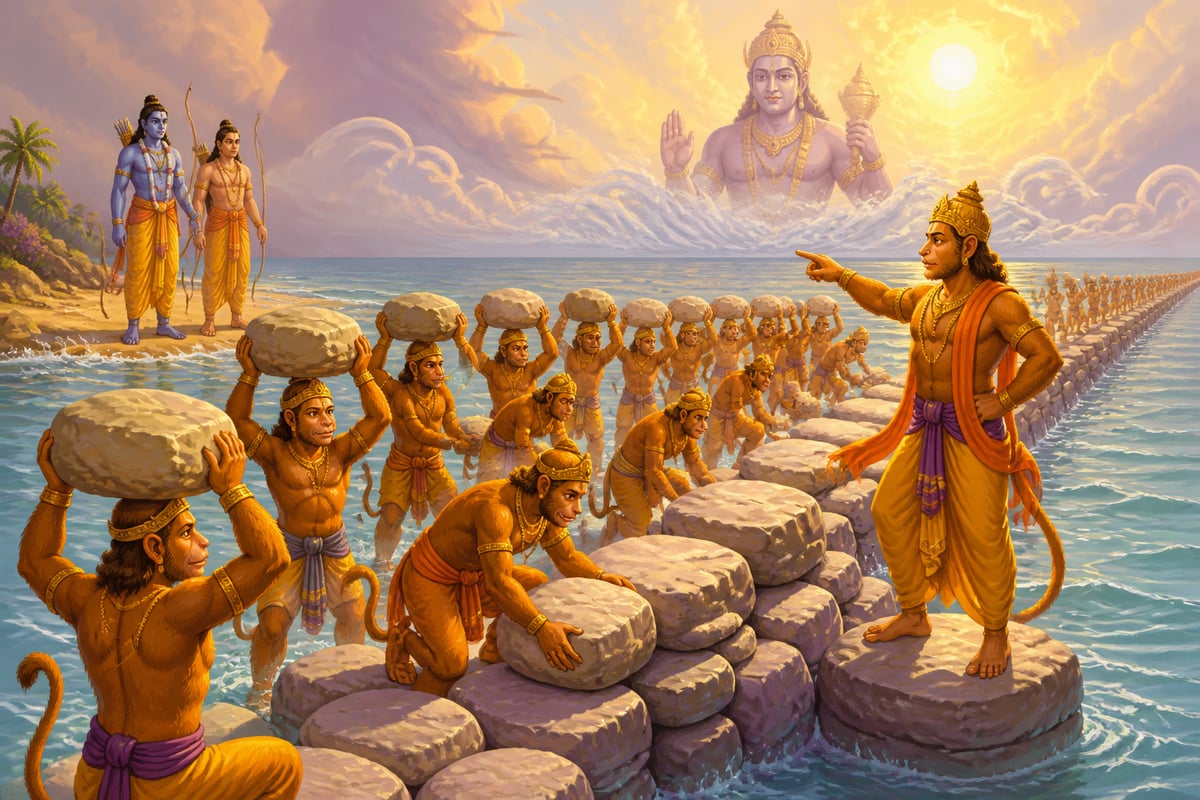
The vanara architects Nala and Neela supervised the construction. The Ramayana describes an army of vanaras (monkey warriors) gathering stones and rocks, inscribing "Rama" on each one. These stones, blessed by Rama's name, floated on the water. Day and night, the army worked, creating a causeway of floating stones across the sea.
The bridge was completed in five days. Rama's army crossed, defeated Ravana, rescued Sita, and returned. The bridge remained, though later texts say it was partially destroyed to prevent Lanka's enemies from using it.
The "Floating Stones" of Rameswaram
At various locations around Rameswaram, pilgrims are shown stones that allegedly float on water, proof, guides claim, of the floating bridge. These stones are typically pumice, a volcanic rock that is light enough to float due to its porous structure.
Skeptics point out that pumice floats naturally and that its presence near Rameswaram doesn't prove anything about a mythological bridge. The floating stones found at Rameswaram could have arrived from volcanic regions through ocean currents.
Believers counter that the presence of floating stones at precisely this location is itself miraculous, confirmation that this was where the floating bridge was built.
The debate illustrates how the same physical evidence can support opposite conclusions depending on one's starting assumptions.
Dhanushkodi: The Land's End
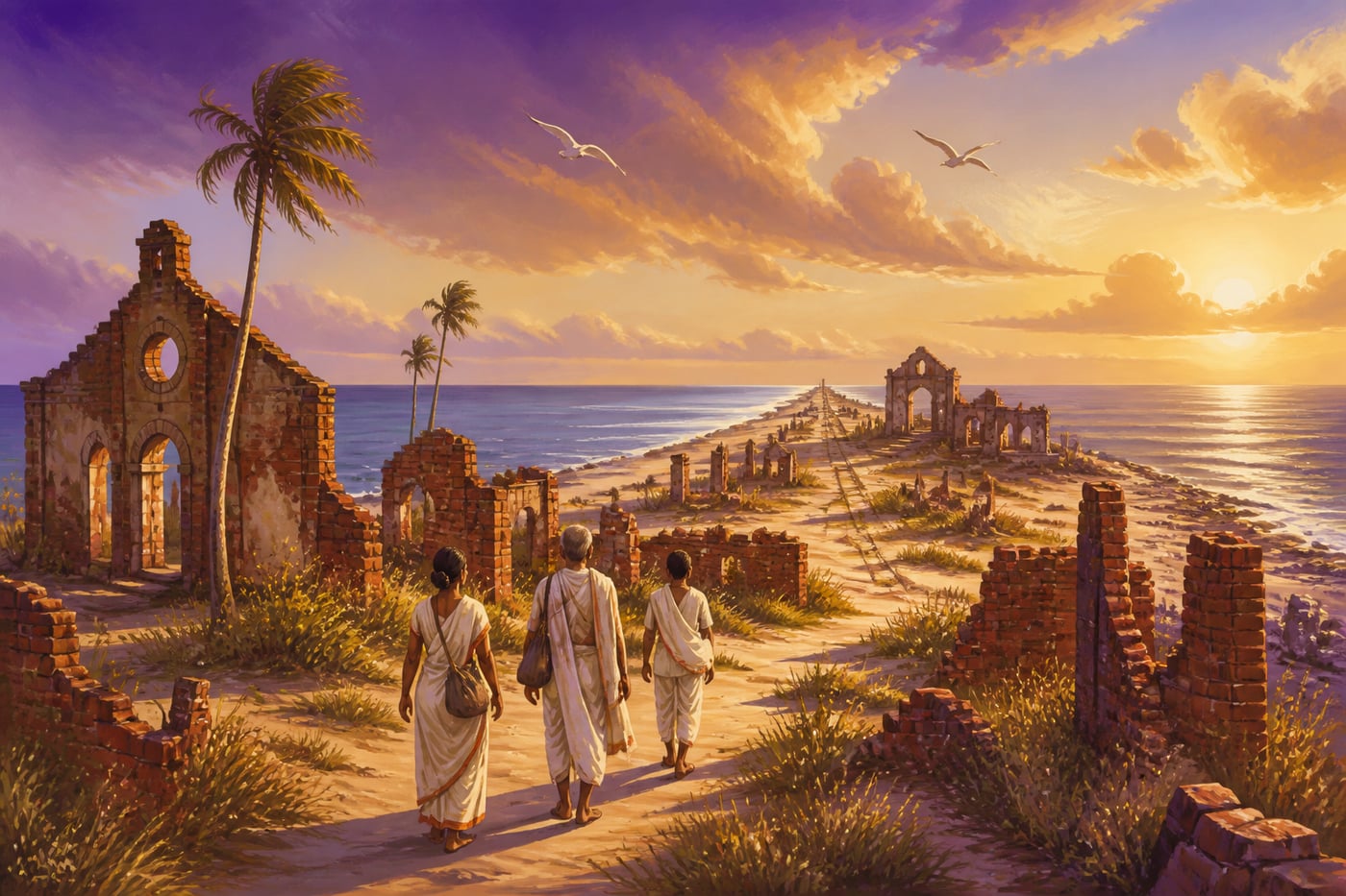
The eastern tip of Rameswaram island is called Dhanushkodi, "the tip of the bow." According to tradition, this is where Rama's bow touched the sea, marking the starting point of the bridge to Lanka.
Until 1964, Dhanushkodi was a thriving town. It had a railway station connecting it to the mainland, a port, customs offices (for traffic to Ceylon, as Sri Lanka was then called), schools, and residential areas. Approximately 5,000 people lived there, and many more worked in the transport industry connecting India to Ceylon.
On December 22, 1964, a massive cyclone struck. Storm surges of over 6 meters swept across the narrow peninsula. The town was obliterated. Over 1,800 people died, including passengers on a train that was swept off the tracks into the sea. The railway station, the port, the houses, everything was destroyed.
The town was never rebuilt. Today, Dhanushkodi is a ghost town, ruins of buildings half-buried in sand, a collapsed railway station, abandoned structures gradually being reclaimed by the sea. The government declared it unfit for habitation due to its vulnerability to future cyclones.
Pilgrims still visit, walking through the ruins to reach the actual tip of land where the Bay of Bengal meets the Indian Ocean. Here, where Rama's bow allegedly touched the water, pilgrims perform rituals, bathe in the confluence of two seas, and contemplate the point from which the bridge to Lanka began.
Gandhamadana Parvatam
About 3 kilometers from the main temple, pilgrims can visit Gandhamadana Parvatam, a small hillock that represents Rameswaram's highest point and one of its most significant pilgrimage sites.
The hillock is named after the Gandhamadana mountain from which Hanuman retrieved healing herbs during the war. According to local tradition, a portion of that mountain rests here, carried by Hanuman as he returned from the Himalayas.
Within a small shrine at the summit, pilgrims venerate what is said to be Rama's footprint (Rama Padam) preserved in the stone. A two-wheeled temple chariot (rath) and Hanuman's chakra (discus) are also displayed.
From the hillock, pilgrims can see the entire island of Rameswaram, the sea on both sides, and on clear days, the shadowy form of the Rama Setu stretching toward Lanka.
The Pamban Bridge
The Pamban Bridge is the engineering marvel that connects Rameswaram island to mainland India. Before its construction in 1914, pilgrims had to cross by boat, a journey that could be dangerous during rough weather.
The original Pamban Railway Bridge was India's first sea bridge, stretching 2.3 kilometers across the Pamban Strait. Its most remarkable feature is the lifting section in the middle, a portion of the bridge that can be raised to allow ships to pass through. This was essential because the strait is an important shipping route.
The bridge created by British engineers transformed the Rameswaram pilgrimage. What had been a difficult journey became accessible to millions. The railway could now carry pilgrims directly to the island, democratizing a pilgrimage that had once been possible only for those with resources and time for boat travel.
A road bridge was added in 1988, running parallel to the railway bridge. Both bridges are engineering achievements, connecting a sacred island to the nation that venerates it.
In recent years, a new modern bridge has been constructed to replace the aging colonial-era structure, ensuring that millions of pilgrims can continue to reach Rameswaram safely.
The Complete Pilgrimage Circuit
While many pilgrims visit only the Ramanathaswamy Temple and its theerthams, the complete Rameswaram pilgrimage includes several additional sites:
Day 1: The Temple Circuit
- Agni Theertham: Sea bathing at dawn
- Ramanathaswamy Temple: 22 theerthams and main darshan
- Corridor circumambulation
Day 2: The Island Circuit
- Gandhamadana Parvatam: Rama's footprint and island views
- Dhanushkodi: The land's end, confluence of two seas, Rama Setu views
- Kothandaramaswamy Temple: Where Vibhishana surrendered to Rama
Extended Pilgrimage:
- Tiruchendur: Murugan temple on the coast
- Kanyakumari: The southernmost tip of India, where three seas meet
Pilgrims who complete this extended circuit have traversed the entire southern geography of the Ramayana narrative, from where Rama worshipped before battle to where the bridge began to where the land itself ends.
The Sethu Samudram Controversy
In 2005, the Indian government proposed the Sethu Samudram Ship Canal Project, a plan to dredge a shipping channel through the Rama Setu, allowing ships to pass directly between India's east and west coasts without sailing around Sri Lanka.
The proposal ignited fierce controversy. Supporters argued that the canal would save shipping time and money, boosting Indian maritime commerce. Opponents argued that the project would destroy a sacred site and an environmentally sensitive marine ecosystem.
The debate became politically charged. Archaeological and geological surveys produced contested results. Legal challenges reached the Supreme Court. The government initially filed an affidavit questioning the historicity of Rama himself (later withdrawn after massive public outcry).
The project remains in limbo. The Rama Setu continues to exist, neither proven nor disproven as Rama's bridge, neither preserved nor destroyed by modern development. It endures as it has for millennia, a physical fact that different people interpret through different frameworks.
What Do We Know?
Let's separate what is established from what is disputed:
Established:
- A chain of limestone shoals connects India to Sri Lanka
- The formation is visible from satellite imagery
- The shoals lie in very shallow water
- The alignment is unusually regular for a natural formation
- The geological age is thousands of years old (exact dating disputed)
- Floating pumice stones exist at Rameswaram
- Ancient texts describe a bridge at this location
Disputed:
- Whether the formation is entirely natural or has human-made elements
- Whether the formation dates to a period when humans could have built it
- Whether floating pumice is evidence of the floating bridge
- Whether the Ramayana account describes historical events
Unknowable (with current evidence):
- Whether Rama was a historical figure
- Whether a bridge was deliberately constructed in ancient times
- Whether the geological formation and the mythological bridge are the same thing
Faith and Geology
The Rama Setu forces a question that pilgrims must answer for themselves: does faith require geological validation?
For some, the geological reality is irrelevant. Rama Setu is sacred because tradition says so, because millions have venerated it as Rama's bridge, because the pilgrimage to Dhanushkodi is spiritually meaningful regardless of how the shoals formed. The sacred geography doesn't depend on scientific verification.
For others, the geological evidence strengthens faith. The unusual alignment, the appropriate age range, the floating stones, these feel like confirmation. Science doesn't disprove the Ramayana; if anything, it makes the account more plausible.
For still others, the geological explanation is sufficient and the mythological overlay is cultural interpretation. The formation is interesting geologically; adding mythology is unnecessary.
All three positions can be held with integrity. The Rama Setu exists. What it means depends on what framework you bring to it.
The Pilgrimage Today
Modern pilgrims reach Rameswaram by train (the Pamban Bridge is one of India's most scenic railway crossings) or by road. From the main town, Dhanushkodi is about 20 kilometers away, accessible by road for part of the journey and then by special vehicles that can traverse the sandy last stretch.
At Dhanushkodi, pilgrims find:
The ruins: Haunting remains of the pre-1964 town, including the destroyed railway station and collapsed buildings.
The confluence: The meeting point of the Bay of Bengal and Indian Ocean, where pilgrims bathe and perform rituals.
The view: On clear days, the beginning of the Rama Setu is visible, the first shoals stretching toward Lanka.
The shore: A wild, beautiful, windswept beach quite different from the temple atmosphere of the main town.
Standing at Dhanushkodi, pilgrims face the same sea Rama faced, look toward the same Lanka he sought to reach, contemplate the same challenge of crossing that seemed impossible until it was done.
The Teaching of the Bridge
What does the Rama Setu teach, whether or not one accepts its mythological origin?
The impossible becomes possible: A sea separated Rama from his goal. The solution seemed impossible, armies don't walk on water. Yet through devotion, ingenuity, and collective effort, a way was found. The impossible became a bridge.
Names have power: According to tradition, the stones floated because "Rama" was inscribed on them. The name of the divine transformed heavy rock into floating support. What we name things matters; blessing transforms substance.
Everyone contributes: The bridge was built not by specialists but by an army of vanaras, each carrying stones, each contributing to the whole. Great works are collective achievements.
Evidence and faith coexist: The Rama Setu exists geologically and mythologically. These are not mutually exclusive. A physical formation can carry spiritual meaning; a sacred story can have geographical correlates.
Destruction and endurance: The 1964 cyclone destroyed a town but could not destroy the pilgrimage. The bridge remains. Some things outlast disaster.
When you stand at Dhanushkodi, you stand at a boundary, land's end, the edge between the known and the unknown, the threshold from which Rama launched toward Lanka. Whatever you believe about how the bridge formed, you stand where millions of pilgrims have stood, facing the same horizon, contemplating the same crossing.
The bridge is there. Whether you walk across it is up to you.
Case studies
The 1964 Dhanushkodi Cyclone: When Land's End Became Ghost Town
On December 22, 1964, a catastrophic cyclone struck the southern coast of India. Dhanushkodi, the small town at the eastern tip of Rameswaram island, stood directly in its path. Wind speeds exceeded 280 km/h. Storm surges rose over 6 meters high. The Pamban railway bridge was damaged. And Dhanushkodi was obliterated. The Rameswaram-Dhanushkodi train, carrying approximately 115 passengers, was swept off the tracks by a massive wave. All aboard perished. The railway station was destroyed. Homes, customs offices, the port, the church, everything was swept away or collapsed. Over 1,800 people died. The survivors evacuated to the main Rameswaram town, never to return. The government declared Dhanushkodi a 'ghost town' and prohibited permanent habitation due to the risk of future disasters. But the pilgrimage never stopped. Even as the ruins accumulated sand and the sea gradually reclaimed the land, pilgrims continued to make their way to the tip. Today, Dhanushkodi is a haunting pilgrimage destination, a place where the sacredness of Rama's bow-tip coexists with the ruins of human habitation, where pilgrims walk among collapsed buildings to reach the point where myth and geography meet.
Dhanushkodi's name means 'tip of the bow,' referring to where Rama broke the Rama Setu after returning from Lanka. The site exists at a literal and metaphorical edge: land's end, where the familiar gives way to the vast unknown of the ocean. In Hindu thought, such liminal spaces are tirthas, crossing points between worlds. The 1964 cyclone that destroyed the town reinforced this liminality. Dhanushkodi became a ghost town, simultaneously inhabited by memory and emptied of life. The pilgrimage tradition continued through the ruins because the sacred geography persists regardless of human settlement. In dharmic understanding, the land itself holds the sacred charge. Buildings may come and go, towns may rise and fall, but the tirtha endures. Walking through Dhanushkodi's ruins is a pilgrimage through impermanence itself.
Dhanushkodi was never rebuilt. The government declared it unfit for habitation, and the ruined town became a pilgrimage site in its own right. Visitors walk through crumbling buildings, the old church, the railway station where the Boat Mail train met its end, all slowly being reclaimed by sand and sea. A road was finally constructed in 2019, replacing the sand track that made the journey difficult. Pilgrim numbers surged. The ruins have become one of Tamil Nadu's most photographed sites, drawing both religious pilgrims seeking the southernmost tip of Rama's story and tourists drawn to the haunting beauty of an abandoned town at the edge of the sea.
Dhanushkodi teaches that sacred geography and human vulnerability are not separate. The land's end where Rama's bow touched the sea is also a place where nature's power destroyed a community. The pilgrimage continues through the ruins, honoring both the mythological significance and the historical tragedy. Sacred places are not immune to destruction; their sacredness may even be deepened by it.
Ghost towns created by natural disasters, from Pompeii to Pripyat near Chernobyl, become pilgrimage sites in their own right. Dhanushkodi's transformation from living town to sacred ruin parallels how disaster sites worldwide accumulate layers of meaning that combine historical memory with spiritual reflection. Dark tourism researchers note that visitors to such sites consistently report experiences closer to pilgrimage than sightseeing.
The 1964 Dhanushkodi cyclone killed over 1,800 people, including all passengers on the Pamban-Dhanushkodi Boat Mail train. Wind speeds exceeded 280 km/h, and the entire town was wiped off the map overnight. It remains India's only officially designated ghost town.
Holding Multiple Truths: Faith and Science in Dialogue
Consider a family visiting Rameswaram: an engineer father, a devout grandmother, and their teenage child studying geology. Standing at Dhanushkodi, looking at the Rama Setu shoals, each sees something different. The grandmother sees Rama's bridge, proof that the Ramayana is historical, that devotion can accomplish the impossible, that she is standing where God's work remains visible. The engineer father sees an interesting geological formation, possibly with some human modification, certainly not a bridge built in five days by monkeys. He appreciates the mythology but doesn't consider it literally true. The teenager, studying both geology and growing up in a devout family, is confused. Must she choose? Can the formation be both natural and sacred? Can the Ramayana be true in ways that aren't historical? Following the Rameswaram example, the family might find that different truths can coexist. The grandmother's faith doesn't require geological validation; the father's analysis doesn't require rejecting the sacred; the teenager can hold both perspectives without choosing. The Rama Setu exists. Its meaning expands to accommodate multiple frameworks. The family can stand together at land's end, each understanding it differently, all moved by the same horizon.
Hindu philosophy has a sophisticated framework for holding multiple levels of truth simultaneously. The concept of adhyaropa-apavada (superimposition and negation) in Advaita Vedanta, or the three levels of reality (paramarthika, vyavaharika, pratibhasika) in Shankara's system, all acknowledge that truth operates on multiple planes at once. The grandmother's faith, the father's science, and the teenager's geology are not competing claims but different levels of engagement with the same reality. The Rama Setu is simultaneously a geological formation (vyavaharika, empirical truth), a sacred site charged with devotional power (also vyavaharika, experientially true), and a pointer toward the ultimate reality beyond all forms (paramarthika). Dharmic tradition does not demand that you choose one lens. It invites you to see through all of them and recognize that reality is always richer than any single perspective.
The family visits Dhanushkodi together. The grandmother performs puja at the water's edge, offering flowers where Rama is said to have broken the bridge. The father photographs the geological formations and explains tectonic processes to his daughter. The teenager collects sand samples and sketches the shoal patterns. That evening, over dinner, they share what they saw. No one tries to convince the others. The grandmother's faith enriches the teenager's scientific curiosity. The father's rational framework gives the grandmother's stories a material foundation. The teenager discovers that holding multiple lenses simultaneously produces a richer understanding than any single perspective. This becomes a family touchstone they reference for years afterward.
The Rama Setu models how faith and science can coexist without requiring one to disprove the other. The geological formation is real. The mythological narrative is real (as narrative). Spiritual meaning is real (as meaning). These don't need to collapse into a single 'truth' that excludes the others. Pilgrimage sites often hold multiple truths simultaneously, historical, geological, mythological, spiritual, and visitors can engage with whichever framework serves their journey.
The science-versus-faith framing that dominates public discourse about origins, evolution, and cosmology misses what pilgrimage sites like Rama Setu demonstrate daily: most people comfortably hold multiple explanatory frameworks simultaneously. A geologist can study the limestone formation's age while a devotee walks its length in prayer. The insistence that one framework must invalidate all others is a modern intellectual habit, not a necessity.
NASA satellite imagery shows the Rama Setu (Adam's Bridge) as a 48-kilometer chain of limestone shoals connecting India to Sri Lanka. Geological dating of the formation varies widely, from 7,000 to 18,000 years, placing it within the range of both natural formation and the traditional dating of the Ramayana.
Living traditions
The Rama Setu remains at the center of ongoing debates about heritage, development, and the relationship between faith and science. The proposed Sethu Samudram Canal project, which would dredge through the formation, has generated intense controversy, with the bridge becoming a symbol of Hindu cultural heritage. Meanwhile, tourism continues to grow, with pilgrims increasingly adding Dhanushkodi to their itinerary. The ruins have become almost as much an attraction as the sacred site itself, a haunting reminder of human vulnerability alongside divine geography. Climate change and rising sea levels add new urgency to discussions about the formation's future. Whatever its origin, the Rama Setu's continued existence is not guaranteed; the same forces that created it may eventually transform or destroy it. For now, it remains, a geological fact, a sacred geography, a political flashpoint, and a pilgrimage destination, visible from space and from the shores of Dhanushkodi, stretching toward Lanka just as tradition says Rama's bridge stretched millennia ago.
- Dhanushkodi Pilgrimage: Pilgrims travel to Dhanushkodi, approximately 20 km from the main temple, to visit the land's end where Rama's bow touched the sea. The journey involves special vehicles for the last sandy stretch. At the tip, pilgrims bathe in the confluence of the Bay of Bengal and Indian Ocean.
- Gandhamadana Parvatam Visit: Pilgrims climb the small hillock to view Rama's footprint, see the temple chariot and Hanuman's chakra, and gain a panoramic view of the island. The site offers the best vantage point to understand Rameswaram's geography.
- Kothandaramaswamy Temple: This small temple marks where Vibhishana surrendered to Rama and was crowned as the future king of Lanka. It survived the 1964 cyclone that destroyed Dhanushkodi, which locals consider miraculous.
- Nambu Nayagiamman Temple: A temple dedicated to the goddess who, according to local tradition, assisted in the construction of the Rama Setu. The temple represents the feminine divine contribution to the bridge-building narrative.
Reflection
- The Rama Setu can be understood as geological formation or divine bridge, or both. How do you hold faith and reason together? Must one disprove the other, or can they coexist as different ways of understanding the same reality?
- The vanara army accomplished something that seemed impossible by collective effort, each contributing their stone. What 'impossible' challenge in your life might become possible through collective contribution? Who are the potential contributors you haven't invited?
- Dhanushkodi was destroyed by a cyclone but remains a pilgrimage site. How does destruction relate to sacredness? Can places become more sacred through tragedy? What does it mean to pilgrimage through ruins?